Stillmes
| Stillmes | ||
|---|---|---|
|
View from the east |
||
| height | 419.5 m above sea level HN | |
| location | Thuringia ( Germany ) | |
| Mountains | Richelsdorf Mountains | |
| Coordinates | 50 ° 59 '1 " N , 10 ° 1' 27" E | |
|
|
||
| rock | Red sandstone | |
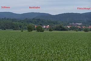
The Stillmes is a 419.5 m high, fully wooded elevation and is predominantly located in the Gerstungen Forest, a closed forest area of the Gerstungen municipality in the Wartburg district in Thuringia . In terms of nature, the mountain is part of the eastern part of the Solztrottenwald in the Richelsdorf Mountains .
The field name "Stillmes" is recorded as a desert in medieval official descriptions. The exact location of this desert is unknown, as investigations had to be omitted due to the border location in the restricted area. During the GDR era, the Gerstung Forest was inaccessible in the restricted area. The Richelsdorf part is located on the steep western slope of the Stillmes. This part is also wooded. In the middle of the slope there is a memorial stone at the top of an aisle.
Individual evidence
- ↑ Official topographic maps of Thuringia 1: 10,000. Wartburgkreis, district of Gotha, district-free city of Eisenach . In: Thuringian Land Survey Office (Hrsg.): CD-ROM series Top10 . CD 2. Erfurt 1999.

