
Strandavatnet
| Strandavatnet | |||||||||
|---|---|---|---|---|---|---|---|---|---|
 |
|||||||||
|
|||||||||
|
|||||||||
| Coordinates | 60 ° 41 '41 " N , 7 ° 51' 29" E | ||||||||
| Data on the structure | |||||||||
| Construction time: | 1952/1953 | ||||||||
| Data on the reservoir | |||||||||
| Altitude (at congestion destination ) | 978 moh. | ||||||||
| Water surface | 24.07 km² | ||||||||
| Reservoir length | 12.2 km | ||||||||
| Reservoir width | 4.5 km | ||||||||
| Total storage space : | 554 Mm³ | ||||||||
| Catchment area | 268.72 km² | ||||||||

The Strandavatnet is a Norwegian dam in the town of Hol , in the province of Viken. The water surface is around 23.75 km². The height of the water surface at full damming is around 978 moh. Due to the 28 m high dam built in 1952/1953, the water level fluctuates and can reach up to approx. 950 moh. sink. In the southeast the lake divides into the two arms Faugelifjorden and Stryknasfjorden . In addition, the Oddelii peninsula juts out into the lake, the highest point of which is the Oddefjellet at 1115 moh. represents.
photos

The frozen Strandavatnet in May 2013, view from the north shore of the lake to the mountains Storeskuta and Folarskardnuten

View from the north shore of the lake to Storeskuta and the Hallingskarvet mountains
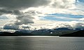
View over the Strandavatnet (September 2012)
Hovet hydroelectric power station

Green energy to Oslo


See also
Individual evidence
- ↑ a b Map of Strandavatnet ( page no longer available , search in web archives ) Info: The link was automatically marked as defective. Please check the link according to the instructions and then remove this notice. , ut.no, accessed December 29, 2011 (Norwegian)