Sumbiarsteinur

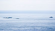
The Sumbiarsteinur ( fär. "Stone of Sumba ") or Munkurin ("the monk") and the Flesjarnar ("the great archipelago " - these are the names of two other archipelagos in the Faroe Islands) are an uninhabited archipelago group that lies south of the Faroe Islands . The dry Sumbiarsteinur archipelago in the southwest of the group at 61 ° 10 '30 ".85 N, 6 ° 40' 23" .77 W the southernmost point of the archipelago.
The actual mainland of the Faroe Islands begins five kilometers to the north with Akraberg on Suðuroy . It is 118 kilometers as the crow flies from Sumbiarsteinur to the northernmost point of the Faroe Islands, Cape Enniberg . The other two outer points of the archipelago are Mykineshólmur in the west and Stapin before Fugloy in the east.
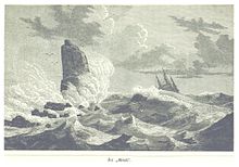
The Sumbiarsteinur is the remainder of the Munkurin ( Danish: Munken ) cliff , which largely collapsed in 1884–85 due to the impact of waves.
Historical report
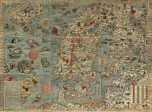
Already on the map of Olaus Magnus from 1539 the rock is clearly visible and bears the Latin inscription "MONACHVS" (= monk). Over 100 years later, in 1673, the first book on the Faroe Islands, Færoæ et Færoa Reserata by Lucas Debes, was published . There the Munk is mentioned several times because of a dangerous ocean current that moves around the cliff like a vortex . There he describes a strong magnetic field that makes all compasses "completely unusable". He lets the experienced local Johannes Joensön have his say:
“First of all, this current is in and of itself very terrible and dangerous, especially when it storms. He draws everything that comes close to the same, and devours such as it were, so that a ship, when it approaches the same, neither can save itself nor escape failure. "
Debes also provides information about the size of the cliff at the time. According to this, the Sumböe Munck is said to have protruded ten fathoms (approx. 18 m) out of the water, which was only three to four fathoms (5.4-7.2 m) deep at the point.
In addition to the compass phenomenon and the raging whirlpool and the shallows there , Debes also reports of the unusual cold that is said to have always prevailed on the cliff. But whether the suspected magnet or the vortex was responsible for it remained a secret to Debes.
literature
- Lucas Jacobson Debes: Natural and Political History of the Faroe Islands . Translated from Danish by CG Mengel, Copenhagen / Leipzig 1757. Newly edited, commented and with an afterword by Norbert B. Vogt: Series of publications of the German-Faroese Circle of Friends ev , Volume 9, Mülheim ad Ruhr, 2005
Web links
- M. Lucas Jacobson Debes Weyland Probst, Preacher and Rector in Thorshaven: Natural and Political History of the Faroe Islands : where the air, land, water, animals, birds, fish etc. the nature, habits, way of life of the inhabitants of these islands and their constitution are described, Copenhagen and Leipzig 1757, digital-sammlungen.de
Individual evidence
- ↑ Announcement No. 306 of May 16, 2002 on the sea territory of the Faroe Islands ( Memento of the original of September 28, 2007 in the Internet Archive ) Info: The archive link has been inserted automatically and has not yet been checked. Please check the original and archive link according to the instructions and then remove this notice. (Legal text, in Danish)
- ↑ Færoæ & Færoa Reserata (Mülheim, Ruhr 2005), note 98
- ↑ In the German translation of 1757 there is alternatively “der München” (p. 18) or “Sumböe Munck” and “der Sumböische München” (p. 27)
- ↑ p. 28
- ↑ p. 50
- ↑ p. 50 f.
Coordinates: 61 ° 20 ′ N , 6 ° 40 ′ W

