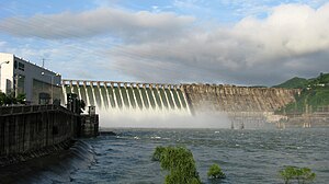
Supung dam
| Supung dam | |||||||||
|---|---|---|---|---|---|---|---|---|---|
| The Supung Dam in 2010 | |||||||||
|
|||||||||
|
|
|||||||||
| Coordinates | 40 ° 27 '40 " N , 124 ° 57' 43" E | ||||||||
| Data on the structure | |||||||||
| Construction time: | until 1941 | ||||||||
| Height of the barrier structure : | 106 m | ||||||||
| Height of the structure crown: | 126.4 m | ||||||||
| Crown length: | 853 m | ||||||||
| Crown width: | 18 m | ||||||||
| Power plant output: | 765 MW | ||||||||
| Data on the reservoir | |||||||||
| Water surface | 274 or 284.5 km² | ||||||||
| Storage space | 14,670 million m³ | ||||||||
| Catchment area | 52 912 km² | ||||||||
| The dam under construction in June 1942 | |||||||||
The Supung Dam (also Sup'ung, Shuifeng, Sui-ho) near Sinŭiju on the Yalu River is on the border between the People's Republic of China and North Korea .
Construction began in 1941 when Korea was a province of Japan and was the fourth tallest dam on earth at the time .
The dam is a 106 m high and 853 m long gravity dam made of concrete. It is 97 m wide at the base and 18 m wide at the crown. The reservoir has a capacity of 14,670 million cubic meters (20,000 million m³ are also given). The area of the reservoir is given as 274 or 284.5 km².
The hydropower plant has six turbines with 100 MW each . It supplies large parts of North Korea and the Lüshunkou (Port Arthur) and Dairen regions in northeast China with energy.
On June 23, 1952, the dam was attacked and partially destroyed by the Americans in the Korean War, along with three other dams . By then, it had supplied 90% of North Korea's electricity, so North Korea's electricity supply was paralyzed for two weeks.
See also
- List of hydropower plants in China
- List of dams in China
- List of dams in the world (North Korea)
- List of the largest dams on earth
- List of the largest reservoirs on earth
- List of the largest hydroelectric plants in the world


