
Suwa lake
| Suwa lake | ||
|---|---|---|

|
||
| Suwa lake | ||
| Geographical location | Nagano Prefecture , Japan | |
| Tributaries | 31 rivers | |
| Drain | Tenryu | |
| Data | ||
| Coordinates | 36 ° 2 '54 " N , 138 ° 5' 3" E | |
|
||
| Altitude above sea level | 759 m TP | |
| surface | 12.81 km² | |
| scope | 17 km | |
| Maximum depth | 7.6 m | |
| Middle deep | 4.7 m | |

Lake Suwa ( Japanese 諏 訪 湖 , Suwa-ko ) is a lake in the central part of Nagano Prefecture in Japan . 31 rivers feed the lake with water, the Tenryū is the only drain.
Omi-watari ( Japanese御 神 渡 り), a rare natural spectacle , occurs at the lake . The lake has a thermal spring under its surface , so the deep water is warm and circulates even when the surface is frozen. Because of the shallow water depth, the pressure on the ice cover results in line-shaped upheavals of 30 cm or more in height. Legend has it that these ramparts are formed by the gods on the way across the lake between the various buildings of Suwa-Taisha .
The lake surface is at 759 m. The surface of the lake is 12.8 km² (24th place in Japan), the circumference is 17 km, the maximum depth 7.6 and the average depth 4.7 m. The lake contains 0.063 km³ of water.
Surrounding communities
Lake Suwa as an artistic motif
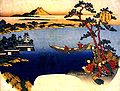
View of Lake Suwa from Hokusai (1760–1849)

Also by Hokusai, part of his 36 Views of Mount Fuji

Lake Suwa in the Nakasendō , Ikeda Eisen


Web links
Individual evidence
- ↑ 湖沼 面積 . (PDF; 114 kB) (No longer available online.) Kokudo Chiriin , October 1, 2015, archived from the original on August 5, 2016 ; Retrieved August 5, 2016 (Japanese). Info: The archive link was inserted automatically and has not yet been checked. Please check the original and archive link according to the instructions and then remove this notice.
- ↑ a b 日本 の 主 な 湖沼 . (No longer available online.) MLIT , 2002, archived from the original on September 12, 2013 ; Retrieved September 15, 2013 (Japanese). Info: The archive link was inserted automatically and has not yet been checked. Please check the original and archive link according to the instructions and then remove this notice.