Sword Beach
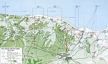
Sword Beach was the name given to a French stretch of coast in Normandy between Ouistreham on the Orne estuary and Saint-Aubin-sur-Mer during the Allied landings in World War II . The landing zone was about five miles long and was divided into four sections named Oboe , Peter , Queen and Roger . It was the easternmost of the Allied landing zones. Juno Beach followed to the west .
Troops of the British 3rd Infantry Division with a strength of approx. 30,000 soldiers landed on D-Day (6 June 1944) at 7:25 a.m. as part of Operation Overlord on this stretch of beach east of the Orne and Caen Canal . They had been assigned British commands to reinforce them . In order to also involve the French in the landing on their own coast, Charles de Gaulle had campaigned in London for participation and had received confirmation of participation. So French troops went ashore on Sword Beach.
The South Lancashire Regiment was assigned to the Peter Sector , the Suffolk Regiment to the Queen Sector and the East Yorkshire Regiment landed in the Roger Sector.
The invasion troops had the task of eliminating the German resistance nests (WN) on and in the coastal towns and then to advance through Ouistreham in the direction of Caen and take the town. Caen was a logistical hub, as all roads and railway lines on the Normandy coast converged here, and therefore a strategically very important destination. In addition, there was the Carpiquet airfield , which was an additional destination. Furthermore, a connection was to be established in the east with the units of the British 6th Airborne Division that had previously landed there as part of Operation Tonga .
The German defenses on Sword Beach were not so well developed. There was the usual at the Atlantic Wall used beach obstacles such as tank traps from sawed iron girders, called Czech hedgehogs , casserole blocks with barbed wired concrete posts and anti-air landings Rommel's asparagus just have so far been less built here been than at the other landing beaches. Machine-gun nests were in the dunes and in the houses of the surrounding towns.
Parts of the German 716th Infantry Division , the 736 and 125 regiments and forces of the 21st Panzer Division , which were able to intervene from the nearby hinterland, lay here for defense . In the east behind the Dives the 711th German Infantry Division was also stationed.
The bridges over the Orne had been taken the night before by British paratroopers under the command of Major John Howard as part of Operation Tonga . These had been set down by gliders.
At the eastern end of the invasion zone, about four kilometers from the beach, DD tanks from landing craft were launched . 32 of the 34 floating tanks reached the bank because the sea was relatively calm there. The DDs worked very well so they could support the landing forces as planned. In doing so, they contributed significantly to the relatively low number of victims there.
Despite the German resistance, the British were able to penetrate inland and unite with the soldiers of the 6th Airborne Division. Since the storm on Caen could not be carried out by a few paratrooper units alone, the troops waited for the units of the 1st Commando Brigade under the command of Lord Lovat , which arrived at the Pegasus Bridge late in the morning . The advance on Caen was considerably hindered by the 21st Panzer Division and later by the 12th SS Panzer Division "Hitler Youth" . It took until the end of the month to take all of Caen.
The losses of the British on the Sword stretch of beach are put at around 700 soldiers.
See also
literature
- Ken Ford: D-Day 1944: Sword Beach & the British Airborne Landings (Praeger Illustrated Military History) , Praeger Publishers, 2004, ISBN 0-275-98265-3 .
- Tim Kilvert-Jones: Sword Beach: 3rd British Infantry Division's Battle for the Normandy Beachhead, 6 June - 10 June 1944 (Battleground Europe) , Pen and Sword Books Ltd., 2001, ISBN 0-85052-673-6 .
- John Keegan : Six Armies in Normandy: From D-Day to the Liberation of Paris; June 6 - Aug. 5, 1944 , Penguin Books , 1994, ISBN 0-14-023542-6 .
- Antony Beevor : D-Day - The Battle of Normandy , C. Bertelsmann, Gütersloh 2010, ISBN 978-3-570-10007-3 .
Web links
Coordinates: 49 ° 18 ′ 23 ″ N , 0 ° 19 ′ 16 ″ W.


