Juno Beach
Juno Beach was the operation name during the Allied landings in World War II for a French stretch of coast in Normandy .
location
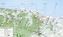
Juno Beach stretched between Saint-Aubin-sur-Mer in the east and a place between the two towns of La Rivière-Saint-Sauveur and Courseulles-sur-Mer in the west. The landing zone was again divided into two sections named Mike and Nan . As part of Operation Overlord , this stretch of beach was assigned to Canadian troops, it was located between the - British - Sword and Gold sections . The 3rd Canadian Division under Major General Rod Keller , supported by Royal Marines Commandos , landed on D-Day (June 6, 1944) on this stretch of beach, which is therefore often called the Canadian beach .
nature
Juno Beach was the second most violently defended beach by the German Wehrmacht after Omaha Beach . Compared to Omaha , Juno Beach itself was less deep, the artificial wall was even higher and the water was much more mined . Omaha, on the other hand, had 30 m high cliffs and was difficult to take because there were positions on them with a free field of fire.
defense
On the German side, this section had been assigned to the 716th Infantry Division under the command of General Wilhelm Richter . There were also eleven heavy batteries with 155 mm guns and nine medium batteries with 75 mm guns. Numerous German bunkers and fortifications faced the landing section; they were particularly concentrated on the Courseulles-sur-Mer side. However, this 716th division consisted mainly of men under 18 and men over 35, largely veterans of the war against the Soviet Union with disabling injuries. This reduced the combat strength of this division considerably.
preparation
The previous night air raids on the German positions initially left no significant damage. Even during the heavy continuous bombardment from the sea between 6:00 a.m. and 7:30 a.m., during which the ship's guns and even tanks and artillery units standing on deck were used, only about every seventh bunker along the beach could be destroyed . When the landing itself was delayed by a good half an hour due to the weather, all of this gave the defenders time to regroup.
landing

The attack was carried out by the 3rd Canadian Infantry Division and the 2nd Canadian Armored Brigade, while the 1st Canadian Paratrooper Battalion was involved in flanking the landings. 14,000 Canadians set foot on French soil on June 6, 1944.
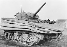
To support the infantry, landing craft brought DD tanks up to about 700 meters to the shore. However, only a few of these floating tanks could be lowered into the water and landed, so they arrived much later than the first wave of soldiers, who therefore suffered high losses. At the eastern end of Juno Beach, the sea was even rougher and so the Canadians who landed there stormed to the shore without any tanks, which cost them a disproportionately large number of victims. In spite of this high blood toll, however, they too finally achieved the breakthrough.
The 7th Brigade, supported by the 6th Canadian Armored Regiment (1st Hussars), went ashore in the western sector called Mike . The 8th Brigade, supported by the 10th Canadian Armored Regiment (The Fort Garry Horse), on the eastern beach section of Nan . The 9th Brigade stayed behind as a reserve for the time being.
In the first hour after the attack, the total Canadian losses amounted to about half of all soldiers who went ashore (and is thus only comparable for this one hour with the world-famous American losses on Omaha Beach. ) The few floating tanks that landed succeeded but then to successfully fight the defensive positions of the bitterly fighting German defenders, not least by shooting down the houses on the beach to which German positions had been ordered shortly before - similar to house-to-house fighting. After the Canadians had finally managed to overcome the wall from the beach side after more than an hour of fighting, they were able to penetrate into the hinterland again with these tanks and quickly reverse the German positions there - insufficiently secured on the land side.

Conquering and fixing
By noon the entire 3rd Canadian Division was ashore and had already advanced a few kilometers into the hinterland, they were then able to take the bridges over the Seulles River and the city of Saint-Aubin-sur-Mer was in Canadian hands at around 6:00 p.m. A group of the 6th Canadian Panzer Regiment was the only one able to reach the set goals in Normandy, they had moved a considerable 15 km inland and even crossed Route Nationale 13 between Caen and Bayeux . Without the infantry , who did not move up to provide support, after a few hours, however, it was considered wiser to retreat to the line of their remaining troops.
At the end of D-Day, the Canadians had managed to penetrate further into French soil than any other Allied unit, although they encountered similar resistance on landing as the Americans on Omaha Beach. On that one day 359 Canadian soldiers lost their lives and another 715 were wounded. Of the merger with the British troops from Sword Beach and Gold Beach , as well as with the Americans from Omaha Beach , which was actually planned on D-Day, only the meeting with the troops of Gold , about 10 km inland , succeeded until the evening of the invasion day . With Sword this took place on the evening of the next day, with Omaha not until June 8th.
The march over Bayeux to the city of Caen could begin, where the battle for Caen brought the decision that the invasion troops could establish themselves permanently in the area on French soil. Only then could the capture of the port city of Cherbourg begin without the invasion troops being completely encircled by the German Wehrmacht on the Cotentin peninsula .
Individual evidence
- ^ D-Day and the Normandy Campaign. In: Canadian War Museum. Canadian Museum of History, accessed November 2, 2016 .
- ↑ a b Canada at D-Day. In: Canadian War Museum. Canadian Museum of History, accessed November 2, 2016 .
literature
- Mark Zuehlke: Juno Beach - Canada's D-Day Victory: June 6, 1944 . Douglas & McIntyre, 2004, ISBN 1-55365-050-6 ( limited preview in Google Book Search).
- Mark Zuehlke: Breakout from Juno - First Canadian Army and the Normandy Campaign . 2011, ISBN 978-1-55365-325-7 ( limited preview in Google Book Search).
- Lance Goddard: D-Day - Juno Beach - Canada's 24 Hours of Destiny . Dundurn Press, 2004, ISBN 1-55002-492-2 ( limited preview in Google Book Search).
- Tim Saunders: Juno Beach - Canadian 3rd Infantry Division - 3rd Canadian & 79th Armored Divisions . Pen & Sword Books, 2004, ISBN 1-84415-028-3 ( limited preview in Google Book Search).
- John Keegan : Six Armies in Normandy - From D-Day to the Liberation of Paris . Random House , 2004, ISBN 1-84413-739-2 ( limited preview in Google Book Search).
- Antony Beevor : D-Day - The Battle of Normandy . C. Bertelsmann Verlag , Munich 2010, ISBN 978-3-570-10007-3 (Original title: D-Day - The Battle for Normandy . Translated by Helmut Ettinger).
Web links
- Juno Beach Center. Juno Beach Center Association, accessed November 2, 2016 (English, French).
- DW Lane: Juno Beach - The Canadians On D-Day. Retrieved November 2, 2016 .
- Jan-H. Maida: Juno Beach. Retrieved November 2, 2016 .
Coordinates: 49 ° 20 ′ 7 ″ N , 0 ° 24 ′ 55 ″ W.

