Syri i Kaltër
| Syri i Kaltër | |||
|---|---|---|---|
 Karst spring Syri i Kaltër |
|||
| location | |||
| Coordinates | 39 ° 55 '25 " N , 20 ° 11' 34" E | ||
| height | approx. 170 m | ||
|
|||
| geology | |||
| Mountains | Mali i Gjerë | ||
| Source type | Karst spring | ||
| Exit type | Source pot | ||
| rock | limestone | ||
| Hydrology | |||
| River system | Bistrica | ||
| Receiving waters | Bistrica → Ionian Sea | ||
| Bulk | 6000 l / s | ||
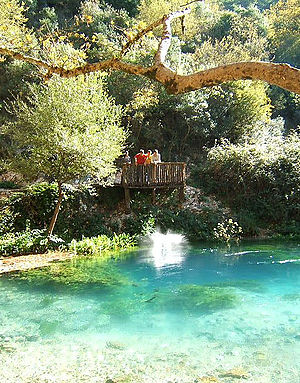
Coordinates: 39 ° 55 '25 " N , 20 ° 11' 34" O Syri i cold (dt black eye.) Is a Karst source on the western slopes of the in Albania located mountain Mali i Gjere . With 6 m³ / s it is the most water-rich source in the country.
The water emerges under high pressure from a spring pot, the exact depth of which has not yet been explored. The temperature is 12.75 ° C with a maximum deviation of only 0.15 ° C. Against the background of the light limestone, the water in the sunlight has a deep blue color, which also gives it its name. The water from Syri i Kaltër flows into the Bistrica , which is dammed shortly after the source to generate energy.
In the summer of 2004 the spring dried up temporarily.
The immediate area (180 ha) is under nature protection and is characterized by oak and plane trees. Fish breeding tanks have been set up near the source and are fed by their water. Today they are no longer used. Although designated as a protected area, the construction of a restaurant at Syri i Kaltër was permitted at the end of the 1990s , which has lost much of its original charm. The source is still a popular destination, which can be reached by car within half an hour from the nearby towns of Delvina and Saranda .
See also
literature
- Perikli Qiriazi et al. a .: Ekosistemet karstike të Shqipërisë. Tirana 1999.

