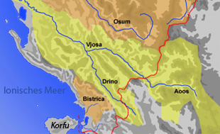
Bistrica (Ionian Sea)
|
Bistrica Bistricë |
||
|
The catchment area of the Bistrica lies south of that of the Vjosa |
||
| Data | ||
| location | Albania | |
| River system | Bistrica | |
| source | in the mountains of Mali i Gjerë | |
| muzzle |
Ionian Sea Coordinates: 39 ° 50 ′ 38 " N , 20 ° 1 ′ 52" E 39 ° 50 ′ 38 " N , 20 ° 1 ′ 52" E |
|
| Mouth height |
0 m above sea level A.
|
|
| length | approx. 25 km | |
| Reservoirs flowed through | Liqen i Bistricës | |
| Communities | Finiq , Saranda | |
|
Canalized run at Mesopotam |
||
|
Liqen i Bistricës reservoir on the upper reaches |
||
The Bistrica ( Albanian also Bistricë ) is a roughly 25 kilometers long, non-navigable river in southern Albania . It is the only significant river in the country that does not flow into the Adriatic but into the Ionian Sea .
The Bistrica rises in the Mali i Gjerë mountains and flows in an approximately south-westerly direction. An important tributary of the Bistrica is the karst spring of Syri i Kaltër . The source pot is a popular destination because of its scenic beauty. Immediately below, the arm of the river to Liqen i Bistricës is dammed. From its source to the entry into the Vurgo plain at Finiq and Mesopotam , the Bistrica has dug a deep valley into the mountains. The road that connects Saranda with Gjirokastra runs in this valley .
Originally the river flowed into the Butrintsee , which is connected to the sea by the Vivar Canal . As part of the improvement of the alluvial plain, the Bistrica was diverted in 1958 and led directly to the sea by means of a cut through a chain of hills as the Çuka Canal a little south of Saranda.
The river, which is always abundant in summer, is used in various ways. Some of the water is used for irrigation. Two hydropower plants were also built on the Bistrica in the 1960s , with a capacity of 2950 KW and an output of 12,910,000 kWh per year for the power supply of the Delvina and Saranda region . For the HEC Bistrica 1 power plant , the water from Liqen i Bistricës is piped around four kilometers underground to the start of the plain near the village of Bistrica . From there, the water is directed in an above-ground channel almost four kilometers parallel to the course of the river and the road to the HEC Bistrica 2 power plant near the village of Mesopotam. Around two and a half kilometers further between the villages of Mesopotam and Finiq, the Turkish company Kürüm International began building the HEC Bistrica 3 power plant in 2014 .
In the following lower reaches the river is mostly canalized.
The name Bistrica is derived from the Slavic * -bistr (= fast).
literature
- Örjan Sjöberg: A contribution to the geography of hydro-electric power generation in Albania . In: Österreichische Osthefte . tape 29 , 1987, pp. 5-27 .
- Mevlan Kabos, Farudin Krutaj et al. (Ed.): Gjeografia fizike e Shqipërisë . tape 2 . Tirana 1991, p. 112 f .
See also
- List of rivers in Albania
- Body name, field name and place name Bystritza
Web links
Individual evidence
- ↑ Annual report Situation of Energy Sector and activity of ERE for 2008. (PDF) (No longer available online.) In: Energy Regulator of Albania. Archived from the original on March 4, 2016 ; accessed on November 8, 2015 .
- ↑ Laureta Roshi: HEC Bistrica 3: Ndalen punimet. In: Reporting the Environment in Albania. August 25, 2014, accessed November 8, 2015 (Albanian).


