Vivar Canal
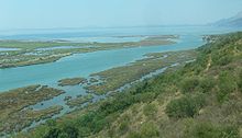
The Vivar Canal is a waterway in the extreme south of Albania . It connects the Butrintsee , a salt water lagoon , with the Ionian Sea . It is a natural body of water that developed into its present form from the Bronze Age (2000–1500 BC) to the Middle Ages. If at the end of the last Ice Age a large bay with wide access to the sea had formed due to the rise in sea level, its southern part silted up completely and the connection to the sea was also reduced to the narrow channel.
The approximately 2.5 kilometers long and 100 meters wide canal runs roughly in an east-west direction. The exit from the lake is on a small peninsula on which the ruins of the ancient city of Butrint are located. The mouth into the sea is on the Strait of Corfu , the narrow strait that separates the Greek island from the mainland. The south bank and the east of the north bank are part of the Butrint National Park . Salt water swamps and wet meadows around the canal are an important bird refuge.
The channel can only be crossed with a ferry from Butrint . It connects the local center of Saranda in the north with the few Albanian towns south of the canal, including Konispol , where there is a border crossing to Greece.
From ancient times to the beginning of the 19th century, the Vivar Canal was of strategic importance. On the one hand, it formed Butrint's natural protection on the south side, and on the other hand, it enabled ships to enter the lake where the protected harbor of the ancient city had been built. The canal could easily be closed to enemy ships. In the 5th century BC The Corfiots had Butrint and the Vivar Canal under their control. In the Hellenistic period , the Buthroten were able to consolidate their autonomy and control the port entrance themselves. Under Roman rule times were peaceful and the port was only used for civil purposes. In Augustan times , an aqueduct was built that crossed the canal and carried water into the city from the south. A large villa rustica was built on the south bank of the canal . In the Middle Ages, the Byzantines fortified the entrance again. Since the 11th century, the area between Normans , Byzantines, local rulers and the Republic of Venice was often contested. A small fort was built on the south bank of the canal, and later a watchtower was built on the north bank by the Venetians. The small fortress of Ali Pasha is located directly at the mouth of the canal and once secured not only the strategic location, but also the rich fishing grounds.
literature
- Neritan Ceka : Buthrotum its history and monuments. Cetis, Tirana 2002, ISBN 99927-801-2-6 .
Web links
- The changing environment (about the genesis of the canal; Enligsch) ( Memento from September 17, 2014 in the Internet Archive )
Coordinates: 39 ° 44 ′ 40 ″ N , 20 ° 0 ′ 43 ″ E


