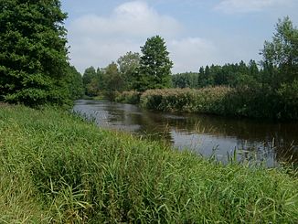
Tämnarån
| Tämnarån | ||
| Data | ||
| location | Uppsala län ( Sweden ) | |
| River system | Tämnarån | |
| origin | See Tämnaren 60 ° 10 '29 " N , 17 ° 24' 32" O |
|
| Source height | 35 m ö.h. | |
| muzzle |
Lövstabukten ( Botnia ) at Karlholmsbruk coordinates: 60 ° 31 '26 " N , 17 ° 38' 55" O 60 ° 31 '26 " N , 17 ° 38' 55" O |
|
| Mouth height | 0 m o.h. | |
| Height difference | 35 m | |
| Bottom slope | approx. 0.58 ‰ | |
| length | approx. 60 km (including source rivers 99 km) | |
| Catchment area | 1,258.1 km² | |
| Small towns | Animal p | |
The Tämnarån is a river in the Swedish province of Uppsala län .
The 60 km long river drains the lake Tämnaren and flows north to the small town of Tierp over to the Gulf of Bothnia and flows Karlholmsbruk in the Lövstabukten .
Including source rivers, the length of the river system is 99 km. The catchment area covers 1258.1 km². There are 6 dams along the course of the river, which are an obstacle for migratory fish. The Tämnarån is suitable for paddling .
Individual evidence
- ↑ SMHI - Sjöareal och sjöhöjd (PDF; 3.5 MB)
- ↑ Sveriges Meteorologiska och Hydrologiska Institut (SMHI) - Län och huvudavrinningsområden i Sverige (PDF; 2.5 MB)
