Tagoloan II
| Municipality of Tagoloan II | ||
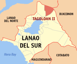
| Location of Tagoloan II in the province of Lanao del Sur | ||
|---|---|---|

|
||
| Basic data | ||
| Region : | Autonomous Region in Muslim Mindanao | |
| Province : | Lanao del Sur | |
| Barangays : | 19th | |
| District: | 1. District of Lanao del Sur | |
| PSGC : | 153638000 | |
| Income class : | unknown (1-6) | |
| Households : | 1064 May 1, 2000 census
|
|
| Population : | 11,169 August 1, 2015 census
|
|
| Coordinates : | 8 ° 7 ' N , 124 ° 26' E | |
| Postal code : | 9321 | |
| Mayor : | Launid Cosain Capal | |
| Geographical location in the Philippines | ||
|
|
||
Tagoloan II (short: Tagoloan ) is a Filipino municipality in the province of Lanao del Sur . It has 11,169 inhabitants (August 1, 2015 census).
Barangays
Tagoloan Ii is politically divided into 19 barangays .
|
|
Web links
- www.tagoloan-lds.gov.ph ( Memento from November 19, 2004 in the Internet Archive )
