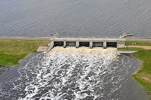
Lake Darling Dam
| Lake Darling Dam | |||||||
|---|---|---|---|---|---|---|---|
| The weir system of the dam | |||||||
|
|||||||
|
|
|||||||
| Coordinates | 48 ° 27 '28 " N , 101 ° 35' 2" W | ||||||
| Data on the structure | |||||||
| Construction time: | 1935 to 1936 | ||||||
| Data on the reservoir | |||||||
| Altitude (at congestion destination ) | 486 m | ||||||
| Water surface | 38.8 km² | ||||||
The dam Lake Darling ( English Lake Darling Dam ) is located in Ward County in the US state of North Dakota . It dams the Souris River into a reservoir. The town of Minot is about 30 km southeast of the dam; the Minot Air Force Base is located about 10 km east.
The dam was built from 1935 to 1936.
Barrier structure
The barrier structure is an earth embankment dam . The weir system consists of five gates.
Reservoir
The normal congestion destination is 486 m (1594.7 ft ); a maximum of 488 m (1601 ft) is permitted. At the normal storage destination, the reservoir extends over an area of around 38.8 km² (9600 acres ). The reservoir is part of the Upper Souris National Wildlife Refuge , which stretches for 56 km (35 miles ) along the river.
In June 2011 there was severe flooding along the Souris River. The discharge of the Souris River at the Lake Darling Dam on June 25, 2011 was 735 m³ / s (26,000 cft / s).
Individual evidence
- ^ A b Upper Souris National Wildlife Refuge, ND. www.recreation.gov, accessed on September 6, 2018 .
- ↑ a b 2011 POST-FLOOD REPORT For the SOURIS RIVER BASIN. (PDF) United States Army Corps of Engineers , pp. 47–48 (39–40) , accessed on September 6, 2018 (English).

