Tano (river)
|
Tano Tanoé |
||
|
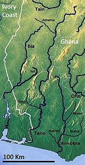
Southern Ghana with the Tano |
||
| Data | ||
| location |
(partly border with Ivory Coast ) |
|
| River system | Tano | |
| Drain over | Aby Lagoon → Gulf of Guinea | |
| source | northeast of Techiman 7 ° 37 ′ 50 ″ N , 1 ° 53 ′ 58 ″ W |
|
| muzzle | on the Ivorian border in the Aby lagoon Coordinates: 5 ° 6 ′ 16 ″ N , 2 ° 56 ′ 2 ″ W, 5 ° 6 ′ 16 ″ N , 2 ° 56 ′ 2 ″ W
|
|
| length | 400 km | |
| Discharge at the Alanda gauge (1530100) A Eo : 15,800 km² Location: 56 km above the mouth |
NNQ (min. Month Ø) MNQ 1965–1978 MQ 1965–1978 Mq 1965–1978 MHQ 1965–1978 HHQ (max. Month Ø) |
5 m³ / s 48.9 m³ / s 144 m³ / s 9.1 l / (s km²) 307 m³ / s 462 m³ / s |
| Right tributaries | Amana, yoyo | |
The Tano is a river in the Akan plain in Ghana .
course
It is 400 km long and flows from Techiman to the Aby Lagoon , where it flows into the Atlantic . In the lower reaches it forms the border between the Ivory Coast and Ghana.
Hydrometry
Average monthly flow of the Tano measured at the hydrological station near Alanda in m³ / s.

spirituality
A local belief holds that the Taakora , one of the greatest Akanic gods, lives at the source of this river.
