
Tasman Bridge
Coordinates: 42 ° 51 ′ 53 ″ S , 147 ° 20 ′ 43 ″ E
|
|
||
|---|---|---|
 |
||
| use | Road traffic , foot traffic | |
| Convicted | Tasman Highway | |
| Crossing of | Derwent River | |
| place | Hobart in Tasmania ( Australia ) | |
| construction | Prestressed concrete bridge | |
| overall length | 1,395 m | |
| width | 17.5 m | |
| Number of openings | 22nd | |
| height | 60.5 m | |
| Clear height | 46 m | |
| vehicles per day | 67,000 | |
| building-costs | 18.5 million AUD | |
| start of building | May 1960 | |
| opening | August 1964 | |
| location | ||
|
||

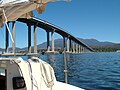
The Tasman Bridge is a bridge in Hobart , Tasmania , Australia . It spans the Derwent River and connects the center of Hobart with the eastern suburbs and the capital's airport. The Tasman Bridge is used by approximately 67,000 vehicles daily and is part of the Tasman Highway .
The Tasman Bridge is a prestressed concrete bridge with a total length of 1395 meters and a width of 17.5 meters, on which there is space for five lanes for motor vehicles and pedestrian and bicycle paths on both sides. At its highest point, the Tasman Bridge has a height of 60.5 meters and a headroom of 46 meters.
history
The first plans for a bridge to cross the Derwent River go back to 1832. However, it was not until 1943 when the first bridge was opened with the Hobart Bridge . Until then, ferries were the only way to cross the river.
The Hobart Bridge was a two-lane pontoon bridge that spanned the Derwent River. The arched, floating bridge had a section at the west end that could be raised to allow passage of ships. This often led to longer waiting times for vehicles on the bridge, which became more and more of a problem as the volume of traffic increased.
The construction of another larger bridge over the Derwent River was therefore planned as early as the early 1950s. Construction of the new Tasman Bridge began in May 1960. The first two lanes were opened to traffic in August 1964 and just a few days later the old Hobart Bridge was closed and dismantling began. The completion of the Tasman Bridge with then four lanes was in December 1964. The official opening took place on March 18, 1965.
bad luck

On the evening of January 5, 1975, the only major accident so far occurred at the Tasman Bridge. At about 9:27 p.m. the freighter Lake Illawarra, loaded with 10,000 tons of iron ore, rammed the bridge. Two pillars and three bridge elements with a total length of 127 meters collapsed. Parts of the bridge elements fell on the ship, which subsequently sank. Seven crew members of the ship and five people whose vehicles fell off the bridge were killed in this accident. The wreck of Lake Illawarra is still under the bridge today and can be dived with permission from the port authority.
As a result of this accident, which destroyed the main connection between Hobart and the eastern suburbs, a ferry connection with several ships, some of which were very old, was set up, which suddenly extended the commute for many city dwellers considerably.
Reconstruction and modernization
Reconstruction of the Tasman Bridge began in October 1975 and took two years. A new guidance system for ships was also installed on the bridge, which uses different colored lights to indicate whether the ships are in the main fairway or how the course needs to be corrected to avoid possible collisions.
In the course of the reconstruction of the bridge, it was also modernized and a fifth lane and a traffic control system were added. This fifth lane is now opened to traffic depending on the rush hour with a changing direction of travel. It is generally open to vehicles in the morning towards the center of Hobart and in the afternoon towards the eastern parts of the city.
Reconstruction and modernization were completed in September 1977. The bridge was officially opened to traffic again on October 8, 1977.
gallery


View of the Tasman Bridge
Tasman Bridge as seen from the Derwent River
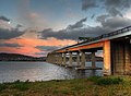
Tasman Bridge at dusk

Access to the Tasman Bridge


Web links
- Picture of the first bridge (1938-1964)
- Pictures of the destroyed bridge on www.parliament.tas.gov.au. (English)
- Statistical data on the bridge at www.abs.gov.au. (English)
- Information about the statistics of the bridge on www.parliament.tas.gov.au. (English)
- 3D images of the sunken Lake Illawarra (English)