Tateyama Kōkū Kichi
| Tateyama Kōkū Kichi | |
|---|---|

|
|
| Characteristics | |
| ICAO code | RJTE |
| Coordinates | |
| Height above MSL | 3 m (10 ft ) |
| Basic data | |
| opening | 1930 |
| operator | Marine Self-Defense Forces |
| Start-and runway | |
| 09/27 | 300 m × 45 m asphalt |
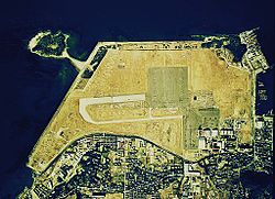
Tateyama Kōkū Kichi ( Japanese 館 山 航空 基地 , German " Tateyama Air Base ", English JMSDF Tateyama Air Base ) is a Japanese military helicopter base outside the city of Tateyama directly on the Pacific coast in Chiba Prefecture in Japan .
history
Tateyama Kōkū Kichi , located on the southern tip of the Bōsō Peninsula , was originally built in 1930 by the Imperial Japanese Navy as a military airfield for the torpedo fighter squadron. Upstream was a seaplane base for the Japanese Kamikaze seaplanes. During the Second World War , the airfield was captured and occupied by the US Army through the 1st US Cavalry Division through tank units and used by the United States Air Force .
In 1953 the base was transferred back to the Japanese government. Tateyama was then converted into the largest helipad in Japan. The six helicopter associations of the Japanese Sea Self-Defense Forces (JMSDF) have been stationed there since 1961 .
The Tateyama Kōkū Kichi helipad is published in the Japanese AIP and AIS Japan under ICAO code RJTE.
Web links
literature
- 防衛 ハ ン ド ブ ッ ク 2009 (平 成 21 年 版) 朝雲 新聞 社ISBN 978-4-7509-2030-6 (Defense Systems Manual)
