Terror Bay
| Terror Bay | ||
|---|---|---|
| Waters | Queen Maud Gulf ( Arctic Ocean ) | |
| Land mass | King William Island | |
| Geographical location | 68 ° 54 ′ N , 98 ° 57 ′ W | |
|
|
||
| width | approx. 7 km | |
| depth | approx. 12 km | |
| Tributaries | Sountag Creek | |
|
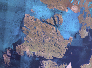
Satellite photo of King William Island with Terror Bay (the westernmost large bay on the south coast) |
||
The terrorist Bay is a bay of the Queen Maud Gulf on the southwest coast of King William Iceland in the Canadian territory of Nunavut .
Its entrance is between Fitzjames Island in the west and the Irving Islands in the east. It is lined with pebble beaches and contains numerous islands and sandbars .
Terror Bay is named after the HMS Terror , one of the two ships on the tragic Franklin expedition from 1845 to 1848. Netsilik Inuit found a tent with dead expedition members and some graves here in 1849. After a long search, the wreck of the HMS Terror was found on September 3, 2016 in the bay that was named after her in the 19th century.
Web links
- Terror Bay , The Atlas of Canada
Individual evidence
- ^ Sailing Directions, Arctic Canada . Volume 3, Government of Canada, Fisheries and Oceans, Scientific Information and Publications Branch, 1986, p. 117.
- ^ Heinrich Klutschak : As an Eskimo among the Eskimos. A description of the experiences of Schwatka's Franklin exploration expedition in the years 1878–1880 . A. Hartleben's Verlag , Vienna [Pest, Leipzig] 1881, p. 83 .
- ^ Peter Watson: Ship found in Arctic 168 years after doomed Northwest Passage attempt . In: The Guardian , September 12, 2016, accessed September 13, 2016.

