
Devil's chapel
| Devil's chapel | ||
|---|---|---|
 Devil's Chapel from the south |
||
| height | 1069 m | |
| location | Germany ( Bavaria ) | |
| Mountains | Ester Mountains | |
| Coordinates | 47 ° 33 '59 " N , 11 ° 10' 53" E | |
|
||

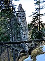
The Teufelskapelle is a larger rock formation on the western slopes of the Estergebirge, west below the Archtal ridge between Zundereck and Archtalkopf . Part of the formation is formed by a free-standing tower and a short straight ridge, and from the south is reminiscent of a nave. The so-called Martinisteig runs south of the formation, but there is no direct access to the 'chapel'. The tower with the cross can only be climbed by climbing.
gallery
tower

entire ridge

.jpg)
Web links
- Devil's Chapel in the Bavaria Atlas