Thatta (District)
| Thatta District | |
| State : |
|
| Province : | Are |
| Seat : | Thatta |
| Coordinates : | 24 ° 30 ' N , 67 ° 50' E |
| Area : | 7th 705 km² |
| Residents : | 979,817 (2017) |
| Population density : | 127 inhabitants per km² |
| Time zone : | PST ( UTC + 5 ) |
| Website : | |

|
|
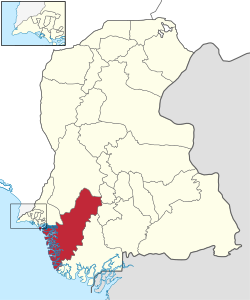
Thatta District is an administrative district in Pakistan in Sindh Province . The seat of the district administration is the city of the same name Thatta .
The district has an area of 7705 km² and according to the 2017 census 979,817 inhabitants. The population density is 127 inhabitants / km². The Sindhi language is spoken by the majority in the district .
location
The district is located in the south of Sindh Province, which is located in southeastern Pakistan. Thatta is located east of the mega city of Karachi .
Administrative division
The district is administratively divided into four tehsil :
history
Thatta was the capital of Sindh from the 14th to the end of the 16th century and one of the most important economic centers of the Indian subcontinent until the beginning of the 18th century. After that, it lost much of its importance compared to the rapidly growing Karachi.
In 2013, the new Sujawal district was created from parts of Thatta, which reduced the area.
Demographics
Between 1998 and 2017, the population grew by 2.61% annually. Around 18% of the population live in urban regions and around 82% in rural regions. 510,279 men, 469,504 women and 34 transgender people live in 184,868 households , which results in a gender ratio of 108.7 men per 100 women and thus a frequent surplus of men for Pakistan.
The literacy rate in the years 2014/15 among the population over 10 years of age was 41% (women: 24%, men: 57%) and thus below the average for the province of Sindh of 60%.
| year | population |
|---|---|
| 1972 | 319,698 |
| 1981 | 399.240 |
| 1998 | 599,492 |
| 2017 | 979.817 |
Web links
Individual evidence
- ↑ a b DISTRICT WISE CENSUS RESULTS CENSUS 2017. August 29, 2017, accessed May 30, 2019 .
- ↑ Pakistani Districts wise Population Census 2017. Accessed May 30, 2019 .
- ↑ Hasan Mansoor: Thatta split to make Sujawal 28th district of Sindh. October 13, 2013, accessed June 1, 2019 .
- ^ Pakistan Bureau of Statistics (2016). Pakistan Social and Living Standards Measurement Survey 2014-15. Government of Pakistan, accessed June 29, 2019 .
