Thorpe St Andrew
| Thorpe St Andrew | ||
|---|---|---|
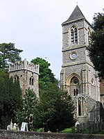
| The Church of St. Andrew. In front of the Victorian building are the ruins of a medieval church that was destroyed in a fire in the 19th century. | ||
| Coordinates | 52 ° 38 ′ N , 1 ° 21 ′ E | |
|
|
||
| Residents | 13,762 (as of 2001) | |
| surface | 7.05 km² (2.72 mi² ) | |
| Population density | 1952 Ew./km² | |
| administration | ||
| Part of the country | England | |
Thorpe St Andrew is a small village and suburb of Norwich in Norfolk . It is about 2 miles from the city center, outside the city limits in the District of Broadland . It is a civil parish which covers an area of approximately 705 hectares. The population in 2001 was 13,762. It is also Broadland's administrative headquarters.
history
Thorpe is mentioned in the Domesday Book , where it is described as “Torp” which is a Scandinavian word meaning “village”. It is believed that the ancient Danes settled in East Anglia in 870 and Norwegians arrived in 1004, who came upstream to Norwich by ship.
There are also indications that Thorpe was occupied by the Romans , as various finds suggest it. In the oldest mentions of the village, it is often referred to as "Thorpe Episcopi" and "Thorpe-next-Norwich". Only later was the name "Thorpe St Andrew" established.
One of East Anglia's worst train wrecks occurred here in 1874, in which 25 people were killed and 75 injured.
Parts of the old town can still be seen along Yarmouth Road leading to Norwich. You can see the old church, a former school, the Rivergarden House, and the Buck House, which has several gables.
Facilities
The village is home to a variety of clubs and organizations including the County Arts Club on Plumstead Road, Thorpe Kite Flyers, Starlight Express Majorettes, and the Oasis Sports and Leisure Center on Pound Lane. Religious groups of all denominations meet regularly all over Thrope.
One school in the village is Thorpe St Andrew High School , which was founded in the 1950s.
In recent years Thorpe St Andrew has expanded in an easterly direction, with the Dussindale Primary School, in 2007 and the Broadland Business Park.
Thorpe St Andrew is also home to a new Norwich radio station called 99.9 Radio Norwich . The studio is near Thorpe River Green and it began service on June 29, 2006.
Streets
Thorpe St Andrew is crossed by the A1042 and A1242. The A1242 or Yarmouth Road is part of the old Norwich to Great Yarmouth road .
Web links
Individual evidence
- ↑ Census population and household counts for unparished urban areas and all parishes ( Memento from June 21, 2009 on WebCite ) ( MS Excel ; 107 kB). Office for National Statistics & Norfolk County Council (2001), accessed December 23, 2011.

