Tiga reservoir
| Tiga reservoir | |||||||
|---|---|---|---|---|---|---|---|
|
|||||||
|
|
|||||||
| Coordinates | 11 ° 26 '14 " N , 8 ° 24' 9" E | ||||||
| Data on the structure | |||||||
| Construction time: | -1974 | ||||||
| Height above valley floor: | 48 m | ||||||
| Crown length: | 6 km | ||||||
| Data on the reservoir | |||||||
| Reservoir length | 29 km | ||||||
| Reservoir width | 8 kilometers | ||||||
| Storage space | 1350 million m³ | ||||||
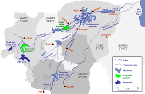
| Map of the Yobe River catchment area | |||||||
The Tiga Reservoir ( Tiga Reservoir ) is a reservoir in Nigeria and the third largest in Africa . It is located in northern Nigeria and was built in the 1970s. The reservoir is part of the Kano River Project I , which irrigates an area of 20,300 hectares and supplies the city of Kano .
Data
The dam, completed in 1974, dams the Kano River , is six kilometers long and up to 48 meters high. The reservoir was completely filled for the first time in 1978. Originally the lake had a capacity of 1970 million m³, by lowering the basin overflow its maximum capacity decreased to 1350 million m³. The annual average amount of water available is 750 million m³.
source
- Ehud Simon: Environmental impact assessment, Kano River irrigation project (Phase I) extension, Nigeria . In: Dan Rosbjerg (Ed.): Sustainability of Water Resources under Increasing Uncertainty . International Association of Hydrological Science, 1997, ISBN 978-1-901502-05-3 , pp. 185-192 .
- The British Dam Society (Ed.): Water Resources & Reservoir Engineering . Thomas Telford, 1992, ISBN 978-0-7277-1692-7 , pp. 321 .


