Tintamarre (island)
| Tintamarre | ||
|---|---|---|
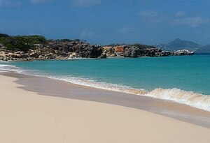
| Beach on the Baie Blanche in the southwest | ||
| Waters | Caribbean Sea | |
| Archipelago | Leeward Islands | |
| Geographical location | 18 ° 7 '10 " N , 62 ° 58' 48" W | |
|
|
||
| length | 2.5 km | |
| width | 980 m | |
| surface | 1.2 km² | |
| Highest elevation | Colline du Soldat 39 m |
|
| Residents | uninhabited | |
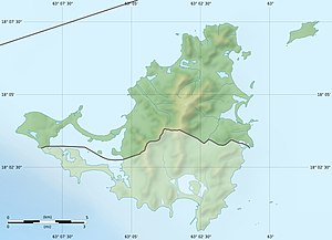
| Map of Saint-Martin, with the nature reserve in the northeast | ||
Tintamarre is an uninhabited island three kilometers northeast of St. Martin in the Caribbean . It is part of the French Antilles , belongs to the French overseas territory of Saint-Martin and includes its easternmost and northernmost land mass.
description
The island is a sedimentary plateau made of shell limestone , which protrudes up to 30 meters from the water in the north and northeast and forms a steep wall there. To the south and southwest, where the coral reef Les Cayes forms a shallow lagoon, the plateau slopes gently down to sea level. To the west, opposite the Quartier d'Orléans on Saint Martin, is a beach that is very popular with day trippers. Behind the beach are the remains of a runway that was created by the founder of the Compagnie Aerienne Antillaise Rémy de Haenen . However, since the Grand-Case runway was built on Saint-Martin, air traffic on Tintamarre has been suspended. 2/3 of the island is covered with dry forests, the rest with xerophilic savannah vegetation , consisting of low bushes, which make the interior of the island difficult to access , except for goats, lizards, crabs and the native coalfish and forest turtles . The birds that nest on Tintamarre also include the magnificent tropical birds .
history
There are different phases in the history of Tintamarre. For 40 years the island was in British possession. Then it moved to France and a period of intensive agricultural use began, which culminated under the French governor Auguste Descoudrelles , who ruled the island from 1763 to 1785. At times up to 150 people lived on Tintamarre. In the first half of the 19th century, the island came increasingly under the influence of the Dutch van Romondt family , whose last representative, Diederik Christian van Romondt, ruled Tintamarre like a king from 1902 onwards. Since Tintamarre was not mentioned in the partition treaty Saint-Martins between Holland and France of March 23, 1648, van Romondt claimed it as Dutch property, introduced Dutch money, ran cattle and received numerous marriage requests from Europe from adventurous women who played the role of an island queen would have liked. In 1931 van Romondt finally sold Tintamarre to Louis Constant Fleming, a dealer from Marigot . After the war, the island flourished as a flight base and at that time had around 20 inhabitants. However, a hurricane destroyed the stationed aircraft on September 1, 1950, and the remains of the facilities were razed to the ground by further hurricanes in 1956 and 1960.
Todays use
The entire island, including a 100-meter wide marine area around the coast, is now part of the Réserve naturelle marine de Saint-Martin nature reserve . Therefore the area is protected by strict regulations. At the same time, however, there is a brisk use for tourist purposes. The beaches are accessible to day trippers and there are several footpaths on the island for exploring. You can visit the buildings of abandoned farms where cotton was still grown in the 19th century . There are also remains of a railway line that was used to mine gypsum and guano .


