
Tiworo Islands
| Tiworo Islands | ||
|---|---|---|
| Waters | Banda Lake | |
| Geographical location | 4 ° 41 ′ S , 122 ° 21 ′ E | |
|
||
| Number of islands | 25th | |

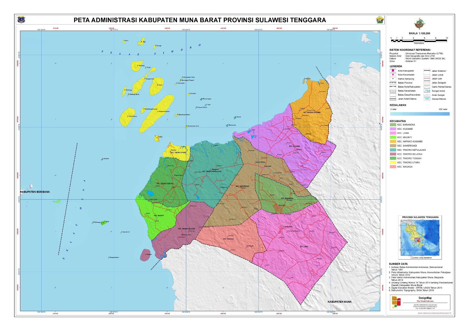
The Tiworo Islands ( Kepulauan Tiworo in Indonesian ) are an Indonesian group of islands near the island of Sulawesi ( Celebes ).
geography
location
The Tiworo Islands are located on the Tiworo Strait between Sulawesi Island and the northwest of Muna Island .
All islands belong to the administrative district ( Indonesian Kabupaten ) Westmuna ( Indonesian Muna Barat ) in the province of Southeast Sulawesi ( Indonesian Sulawesi Tenggara ), which was founded in 2014 .
19 islands belong to the district ( Indonesian Kecamatan ) North Tiworo ( Indonesian Tiworo Utara ): The largest island of the archipelago is Bangkomalampe . To the north are Latoa , Pasipi and Masalokaan , further north are Sanggaleang , Maloang and Maloang Kecil , then Simuang and Tasipi and finally Tiga , Santigi and Bero . South of Bangkomalampe are Balu with Santiri , the largest settlement and the islands of Belanbelan Besar (Großbelanbelan) and Belanbelan Kecil (Kleinbelanbelan) . East of Latoa is a small chain of islands: Kayuangi , Kayuangi Tengah (Central Kayuangi ) and Kayuangi Utara (Northern Kayuangi ) . To the south of it is the islet of Mandike .
Five islands in the southeast belong to the Tiworo Kepulauan district ( German Tiworo Islands ): Masaringan (Wasaringan), Indo and Lweame Besar in the northwest and Katela and Ransaweta in the southwest, near the coast of Muna.
Off to the southwest, at the entrance to Muna Street, is the small island of Nangku . It belongs to the district of Zentralaltiworo ( Indonesian Tiworo Tengah ).
climate
The climate is tropical with average temperatures between 25 and 27 ° C. The year is divided into a rainy season of November and March, in which the wind blows from the Asian continent and high humidity brings precipitation, and a dry season between May and October. Now dry winds come from Australia . In 2005, 128 rainy days were registered with a total of 1942 mm of precipitation. The heaviest rainfall was in December with a total of 296 mm. There were only four rainy days in August with a total of 31 mm.
The temperature of the sea water is between 27 and 29 ° C, the salt content is 3.3 to 3.6% and the pH value 7.0 to 7.4. The visibility under water varies from 12 to 22 meters.
fauna and Flora
The area has been a marine reserve since 2004. Mangroves and diverse coastal and marine resources can be found here. Numerous species are endemic, such as various jellyfish, anemones, sponges, sea cucumbers, snakes, starfish, crabs and crabs, and coral fish. The protection zone is intended to secure the tourist value of the region.
The coral reef of Masaringan is largely destroyed. Only 33.27% are covered with living corals. Blame could dynamite fishing have been.
Residents
1595 people live in Santiri (2010 census). Tasipi has 684, Tiga 831, Bero 415, Mandike 393 and Santigi 252 inhabitants.
Above all, the Muna dialect is spoken , as it is common in the northwest of the island of Muna, while the population of the archipelago is a mixture of the ethnic group of the same name (also called Wuna ), Bugis , Bajau and people from the island of Kadatuang (southwest of Bau -Bau ) are.
Individual evidence
- ^ Map of Westmuna , accessed November 13, 2016.
- ↑ Mapcarta: Selat Tiworo , accessed on November 13, 2016.
- ↑ a b c d Konservasi Kawasan dan Jenis Ikan: Marine Protected Area Form , accessed on November 13, 2016.
- ↑ Penduduk Indonesia menurut desa 2010 ( Memento from March 27, 2014 in the Internet Archive ) (Indonesian; PDF; 6.0 MB), accessed on January 26, 2013
- ↑ René van den Berg: [bahasamuna.org/ind/mlsp-dl/234/12376/41318?s=1 Muna Dialects and Munic Languages: Towards a Reconstruction ], p. 24, Leiden University, Summer Institute of Linguistics, 1991 .