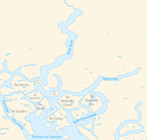
Toba Inlet
| Toba Inlet | ||
|---|---|---|
|
Situation map |
||
| Waters | Desolation sound | |
| Land mass | Mainland Canada | |
| Geographical location | 50 ° 25 ′ N , 124 ° 36 ′ W | |
|
|
||
| width | 2.5 km | |
| length | 35 km | |
| Tributaries | Toba River , Tahumming River | |
|
A waterfall |
||
Toba Inlet is a fjord on the coast of British Columbia that leads off the Desolation Sound . It is 2.5 km wide and 35 km long. The fjord begins in Sliammon First Nation , where the Toba River flows, and ends north of East Redonda Island .
history
The first Europeans arrived in the area with the joint expedition of George Vancouver for the English and Dionisio Alcalá Galiano for the Spanish. On June 25, 1792, Vancouver sent three boats to explore the area from the base established on West Redonda Island . One of them left the base with Cayetano Valdés y Flores on June 25th and returned on June 27th. Valdés reported that the fjord was very deep and surrounded by steep slopes and mountains. He also reported from Brett on the east side (span. Tabla ) with drawings that he called “hieroglyphics of the natives” and found many uninhabited villages. He named the bay Boca de las Tablas after the board . To confirm the Spaniard's report, the British later explored the bay as well. The name of Valdés was taken over, but due to a mistake by a Spanish cartographer for Canal de la Toba , i.e. Toba Inlet.
See also
Web links
Toba Inlet . In: BC Geographical Names (English)
Individual evidence
- ^ Andrew Scott: The Encyclopedia of Raincoast Place Names: A Complete Reference to Coastal British Columbia . Harbor Publishing, Madeira Park, BC 2009, ISBN 978-1-55017-484-7 , pp. 595-596 (English).


