Torre Caligo
| Torre Caligo | ||
|---|---|---|
| Waters | Venice lagoon | |
| Geographical location | 45 ° 33 ' N , 12 ° 36' E | |
|
|
||
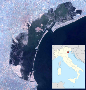
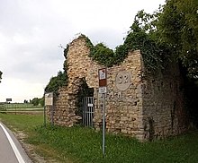
The Torre del Caligo (also Torre del Caìgo) is the remnant of a medieval tower on the northern edge of the Venice lagoon , which was built by the Venetians west of Jesolo (today on Via Drago Jesolo). The remains of the complex lie on the bank of the Caligo Canal, which was filled in in the 17th century and which flows into the Sile River. Today only a ditch, the former canal only represents the border between the municipalities of Jesolo and Musile . It was between three and four meters wide. Because of the diversion of the Piave, the land on the other side of the canal had become swampy and the forests no longer usable. This made the canal that connected the Jesolo lagoon with the Piave from 1443/44 superfluous. Together with another tower on the other side of the canal, according to a map from the 18th century, the tower formed a control point. Up to the 16th century both were referred to together as "Turris de Plave". This tower system was used to control and monitor the northern edge of the lagoon, and thus the extensive connection between Ravenna , Chioggia and Caorle . This connection ran partially parallel to the Via Annia , a Roman road that appears in the sources as "fossa Popilliola".
The tower belonged to a former fortress of a medieval settlement. The tower and the fortress were partly built on the previously existing structures from the time of the Roman Empire and included older ancient remains. In the Middle Ages, the tower was used by the Republic of Venice as a toll and customs post, as well as to control the import of wood. According to a local legend, St. Romuald († 1027) built a monastery here. Inside the tower there are crosses, a tabernacle, perhaps the rest of a small altar, which indicate the corresponding use in recent history.
In a south-westerly direction there was a similar tower at the mouth of the Lio Maggiore and also a whole series of other similar structures along the Canale Revedoli until the 16th century, none of which have survived. They appear in the sources under names such as "torre da Fine" or "tor de Rodevol". Several sacred buildings were later built in the immediate vicinity of the tower . The tower had not been used since the end of the Middle Ages and was increasingly falling into disrepair; a bridge crossed the canal at the beginning of the 17th century. In 1713 the complex was still listed as an intact structure on a map of the region. As a result, the stones and remains of masonry were removed and used as building material. Today only a ruin is preserved. Around 1930 a supply line for drinking water was built there, which meant that Jesolo was no longer dependent on the salty water of the Piave.
The remains of the complex were protected as an archaeological site according to the Italian Monument Protection Ordinance 42/2004.
Remarks
- ^ Camillo Pavan: Sile. Alla scoperta del fiume, Immagini, storia, itinerari , 2nd ed., Treviso 1991, p. 159.
- ^ Camillo Pavan: Sile. Alla scoperta del fiume, Immagini, storia, itinerari , 2nd ed., Treviso 1991, p. 147.
- ↑ Idrotecnica (1984), p. 23.
- ↑ Raffaello Vergani: Brentella. Problemi d'acque nell'alta pianura trevigiana dei secoli XV e XVI , Ed. Fondazione Benetton Studi Ricerche, 2001, p. 42.
- ↑ Torre Caligo, Jesolo Paese , archive.org, February 16, 2011.
- ^ Camillo Pavan: Sile. Alla scoperta del fiume, Immagini, storia, itinerari , 2nd ed., Treviso 1991, p. 162.

