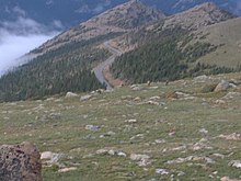
Trail Ridge Road
As Trail Ridge Road , also Trail Ridge Road / Beaver Meadow National Scenic Byway , of the 77 km road section of is US Highway 34 in Rocky Mountain National Park from Estes Park and Grand Lake (Colorado) called. Recognized as the National Scenic Byway for its tourist importance , the road is the highest continuous highway in the United States. About 18 kilometers are above the tree line, the highest point of the road is at 3713 meters.
Route description
From the Kawuneeche Visitor Center in the southwest of the park, Trail Ridge Road leads north through the Kawuneeche Valley . The valley offers numerous starting points for hikes, trailheads , which lead along the Colorado River or on the heights.
After the Colorado River Trailhead, the road climbs and turns east to Farview Curve, a popular vantage point from which you can see the Kawuneeche Valley and the Never Summer Mountains . After a further three kilometers you reach the Milner Pass , which forms the North American continental watershed between the Atlantic and the Pacific.
Shortly after the Alpine Visitor Center, heading east, you will reach the highest point on the road at 3713 meters (12,183 feet). Trail Ridge Road then descends eastward past the Rock Cut, Forest Canyon and Rainbow Curve lookouts. The winding road ends at Estes Park, where US Highway 34 and US Highway 36 meet.
In the lower areas, the road leads through mountain forest of aspen and yellow pines . With increasing altitude, the mountain forest gives way to subalpine vegetation of dense firs and spruces . Windy weather prevails above the tree line. The tree-free area offers a wide view of the Rocky Mountains .
History of origin
In 1921 the Fall River Road , the first drivable access to the highlands of the Rocky Mountain National Park, was opened. The single-lane road proved to be unsuitable for motorized traffic because of the steep incline (up to 16% in places) and the tight curves.
The National Park Service and the Federal Highway Administration subsequently agreed on a new route. Work on the new Trail Ridge Road began in 1929. The first section between Deer Ridge and Fall River Pass was completed in 1929. The new maximum gradient of the road is no more than 7% today. The second section through the Kawuneeche Valley to Grand Lake in the southwest of the park was opened in 1938.
Due to the prevailing climatic conditions, work on the construction of the road could only be carried out during the summer months between mid-June and mid-October.
Web links
- National Park Service (Engl.)
- Trail Ridge Road , website in German
Individual evidence
- ↑ a b National Park Service: Trail Ridge Road
Coordinates: 40 ° 23 '40.8 " N , 105 ° 42' 38.9" W.


