Trowlock Island
| Trowlock Island | ||
|---|---|---|
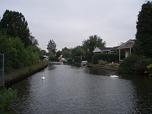
| View to Trowlock Island | ||
| Waters | Thames | |
| Geographical location | 51 ° 26 ′ N , 0 ° 19 ′ W | |
|
|
||
| Trowlock Island and the mainland | ||
Trowlock Island is an inhabited island in the Thames 450 m upriver from Teddington Lock less than 10 m from the north bank in the London Borough of Richmond upon Thames , England .
location
Hampton Wick is the closest settlement on the island.
On Trowlock Island there are 29 bungalows and the club house and sports hall of the Royal Canoe Club . The island is approximately 535 m long and has a path in the middle with houses on either side. Behind the last house there is a small wooded area with moorings. Access to the island is via a hand-operated chain ferry .
history
Like many other islands in the Thames, this island has changed shape over time. John Rocque's 1746 map shows three separate islands. The name of the island is derived from Trow , a type of barque . Harry Gibbs' boat building took place on the island in 1910.
business
Trowlock Island Limited manages the island and common infrastructure. The board of directors is elected by the shareholders - each house or piece of land has a number of voting shares. The homeowners and the Royal Canoe Club own the company.
Wildlife is abundant on the island and on the banks of the Thames.
See also
Web links
- Thames at Trowlock Island at environment-agency.gov.uk
Individual evidence
- ↑ Explore Surrey's islands of the River Thames. Surrey Life, December 18, 2014, accessed March 22, 2020 .
- ↑ Melissa Lawford: The Thames' islands attract maverick homeowners. Financial Times, March 19, 2019, accessed March 22, 2020 .
- ↑ Grid reference finder measurement tools
- ↑ a b Map search ( Memento of the original from April 24, 2012 in the Internet Archive ) Info: The archive link was inserted automatically and has not yet been checked. Please check the original and archive link according to the instructions and then remove this notice. at the English Heritage Ordnance Survey .
- ^ Rosie Murray-West: Islanders in court after refusing to pay £ 5,000 ferry fee . In: The Daily Telegraph , January 25, 2006. Retrieved January 7, 2009.
- ^ British Library . An Exact Survey of the Citys of London, Westminster, ye Borough of Southwark, and the Country near Ten Miles round [map], 1769 print, scale 1: 11520. Cartography by John Rocque .
- ^ Frederick Samuel Thacker: The Thames Highway. A history of the inland navigation . FS Thacker, Holborn / London 1914, LCCN 15-024238 , p. 59 ( online ).
- ^ Livelihoods, Leisure and the Islands . The Twickenham Museum. Archived from the original on May 23, 2003. Retrieved June 30, 2013.


