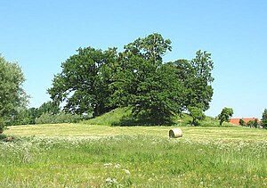
Stuer tower hill
| Stuer tower hill | ||
|---|---|---|
| Castle type : | Niederungsburg, moth | |
| Conservation status: | Burgstall, castle hill | |
| Place: | Röbel / Müritz -Stuer | |
| Geographical location | 53 ° 22 '44.7 " N , 12 ° 20' 31.8" E | |
|
|
||
The Tower Hill Stuer is an Outbound Turmhügelburg (Motte) in farmland 200 meters east of the Church of Stuer in the small town Röbel / Müritz , seat of the Office Röbel-Müritz in the area of the lake district in Mecklenburg-Vorpommern .
From the former Motte plant is still tower hill having a diameter of about 50 meters on a 14 by 14 meter plateau of large machined fieldstone. The keep with 2.3 meter thick walls had a floor area of 11 by 11 meters.
literature
- Uwe Schwarz: The fortifications of the 13th to 16th centuries in the Neubrandenburg district. Publishing House of Science, 1987.

