Tzoumerka
| Tzoumerka (Τζουμέρκα) Athamanikα (Αθαμανικά) |
||
|---|---|---|
|
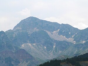
Kakarditsa, main peak of the Tzoumerka massif |
||
| height | 2429 m | |
| location | Epirus and Thessaly regions in Greece | |
| Mountains | Southern Pindus Mountains | |
| Coordinates | 39 ° 25 '50 " N , 21 ° 8' 53" E | |
|
|
||
Tzoumerka ( Greek Τζουμέρκα ( n. Pl. )), Also Athamanika (Αθαμανικά), is a mountain range of the southern Pindos Mountains in Greece that extends in a north-south direction . The mountain massif is located southeast of the Lakmos massif and continues this. The north-south extent of the Tzoumerka is approx. 40 km, the east-west extent 15 to 20 km. The highest peak, which is occasionally listed as a separate massif, is the Kakarditsa at 2,429 m above sea level . In the west of the Tzoumerka massif, the Arachthos river flows from north to south to its mouth in the Ambracian Gulf , in the east the Acheloos river flows from north to south to its mouth in the Ionian Sea . Thus, the Tzoumerka massif represents the watershed between these two great rivers in Greece.
Tzoumerka is also the name of the municipal district with headquarters in Pramanda (Πράμαντα), which includes the villages of Agnanda (Άγναντα), Katarraktis (Καταρράκτης), Kalarites (Καλαρίτες) and Sirako (Σιράκοit) with their traditional stone architecture.
Kipina Monastery, founded by monks in 1212 and consecrated to the Virgin Mary, sits enthroned in the rock high above the Matsoukiotiko (Ματσουκιώτικο), which is now abandoned and can be visited.
Development
The deep valleys of Arachthos and Acheloos represent topographical barriers that make it difficult to develop the Tzoumerka with traffic. In addition to the Plaka Bridge (Gefyras Plaka), which acts as a gateway to the Tzoumerka from the north and west, four other road bridges cross the Arachthos. In the east, roads lead from the Thessalian plain to Tripotama and Mesochora. The few roads that cross from east to west are not passable in winter, with the exception of the Arta - Mesochora - Trikala connection on the southern edge. The asphalt road over the Barros Pass, which is usually open from May, is of particular importance. It connects the upper Acheloos valley with Matsouki or Kalarites.
tourism
The mountains of the Tzoumerka have a certain tradition as a hiking area, but are far less frequented than the Vikos-Aoos region further north . The mountain huts, known as “katafigio”, which are mostly under municipal administration, are witness to tourist activities. Some are currently unused, others offer services for mountain sports enthusiasts and those seeking relaxation under the leadership of private tenants. There are numerous hotels available to overnight guests, especially in the western Tzoumerka around Pramanda . In the village of Frasta not far from the Plaka bridge, a campsite is open all year round.
The potential for hiking tourism is great. Gravel roads that can be driven by car lead up to the highest regions. Some hiking trails are marked. The connection between the villages of Matsouki , Kalarites and Sirako along old trade routes is particularly rewarding in terms of landscape . The cultural heritage is concentrated around the three former economic centers. The original structure of Kalarites and Sirako has largely been preserved or has been restored in the last few decades.
Rafting on the Arachthos, offered by several companies, is of great tourist importance . The rivers Arachthos , Kallaritikos and Acheloos are the destination of white water enthusiasts from all over Europe in spring.
In recent years there have also been sporting events that have attracted visitors from all over Greece and Europe. The Ski and Climb Festival took place for the first time in March 2016, as part of the Trekking Athamanicus, multi-day hiking tours are conducted through the summit region, the Pindos Outdoor & Kayak Festival based on Arachthos is aimed at white water sports enthusiasts, mountain hikers and mountain bikers.
Nature and conservation
The National Park Εθνικό Πάρκο Τζουμέρκων, Περιστερίου και Χαράδρας Αράχθου (National Park Tzoumerka, Peristeri and Archatos Gorge) has existed since 2009. It lies essentially within the boundaries of the previously designated Important Bird Area (IRA) Tsoumerka and the Natura2000 protected area Athamanikon Mountains and covers around 820 km². The park administration is located in Ioannina , the development of the national park is scientifically supported by the university of this city. Branch offices and documentation centers are located in the larger towns within the park.
Web links
- OECD Territorial Reviews: Tzoumerka, Greece Online
- Εθνικό Πάρκο Τζουμέρκων, Περιστερίου και Χαράδρας Αράχθου (Greek)
- Map of the Athamanika Massif from the Greek Tourism Organization (GNTO)
- Map of the Lakmos Massif from the Greek Tourism Organization (GNTO)
Individual evidence
- ↑ Via Natura Camp. Retrieved August 30, 2016 .
- ↑ Arachthos and Acheloos for 4-paddlers. Retrieved August 30, 2016 .
- ^ Ski and Climb Festival. Retrieved August 30, 2016 .
- ↑ Trekking Athamanicus. Retrieved August 30, 2016 .
- ↑ Pindos Outdoor & Kayak Festival. (No longer available online.) Archived from the original on August 28, 2016 ; accessed on August 30, 2016 . Info: The archive link was inserted automatically and has not yet been checked. Please check the original and archive link according to the instructions and then remove this notice.
- ^ National park website


