Ugāle
| Ugāle | ||
|---|---|---|
 Help on coat of arms |
|
|
| Basic data | ||
| State : |
|
|
| Landscape: | Courland ( Latvian : Kurzeme ) | |
| Administrative district : | Ventspils novads | |
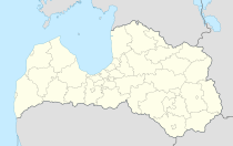
| Coordinates : | 57 ° 17 ' N , 22 ° 1' E | |
| Residents : | 1,717 | |
| Area : | ||
| Population density : | ||
| Height : | 40 m | |
| Website: | ||
| Post Code: | ||
| ISO code: | LV-106 | |
Ugāle is a settlement in Ugāle Municipality, Ventspils District . With 1,717 inhabitants, it is the largest in the district.
Ugāle is located on the left bank of the Engure River and at the intersection of the Riga - Ventspils railway line and the A10 and P123 motorways. It is 39 km from the center of Ventspils and 150 km from Riga.
history
The oldest mention of the place in Courland is from 1253.
Culture and sights
- Lutheran church, built 1691–94, with the oldest preserved organ in the Baltic States by Cornelius Rhaneus from 1701
- Catholic Church
- Russian Orthodox Church
- Culture house
- Middle school
- music school
- Organ building workshop, since 1992, the only one in Latvia that builds new organs.
Web links
Commons : Ugāle municipality - collection of images, videos and audio files
- Statistical and geographical information LĢIA vietvārdu datubāze
Individual evidence
- ↑ Lutheran Church in Ugāle (German)
- ↑ Organ building workshop in Udāle (German)


