Ula (Daugava)
|
Ula У́ла, Улья́нка, У́лла (Ulla) |
||
|
Ula near the mouth |
||
| Data | ||
| location | Vitebskaya Woblasz ( Belarus ) | |
| River system | Daugava | |
| Drain over | Düna → Baltic Sea | |
| origin |
Lepeler See 54 ° 53 ′ 26 ″ N , 28 ° 41 ′ 40 ″ E |
|
| Source height | 145 m | |
| muzzle | at Ula in the Düna coordinates: 55 ° 14 ′ 12 " N , 29 ° 14 ′ 12" E 55 ° 14 ′ 12 " N , 29 ° 14 ′ 12" E
|
|
| Catchment area | 4090 km² | |
| Drain |
MQ |
25.4 m³ / s |
| Left tributaries | Chotinka | |
| Right tributaries | Lukomka , Usweika , Swetschanka | |
| Small towns | Lepel , Tschaschniki | |
| Communities | Ula | |
|
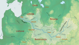
Location of the Ula in the catchment area of the Daugava |
||
The Ula ( Belarusian У́ла, Улья́нка ; Russian У́лла ( Ulla )) is a left tributary of the Düna in the Wizebskaja Woblasz in Belarus .
The Ula forms the outflow of the Lepeler See . It flows through the town of Lepel on the southern shore of the lake in an easterly direction. At Tschaschniki it makes a sharp turn to the north. It then flows in a predominantly northerly direction and flows into the Daugava at the homonymous town of Ula , 60 km west of Vitebsk .
The Ula has a length of 123 km. The Ula has a catchment area of 4090 km². The mean discharge is 25.4 m³ / s.
In the 19th century there was a connection between the Baltic Sea and Düna, Ula, the Berezina canal system to the Dnieper and into the Black Sea . The waterway lost its importance due to the expansion of rail and road connections. The hydraulic engineering systems fell into disrepair. This route is only partially passable for excursion and pleasure boat traffic.

