Ulawun
| Ulawun | ||
|---|---|---|
|
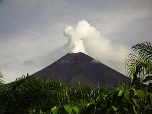
The Ulawun seen from the southeast |
||
| height | 2334 m | |
| location | New Britain | |
| Mountains | Bismarck volcano group | |
| Coordinates | 5 ° 3 ′ 0 ″ S , 151 ° 20 ′ 0 ″ E | |
|
|
||
| Type | Stratovolcano | |
| Last eruption | 2019 | |
The Ulawun (also: The Father , Ulawon , Uluwun , Vatr , North Son ) is a volcano on the island of New Britain, which belongs to Papua New Guinea . With a height of 2334 m, it is one of the highest mountains on the island.
The volcano belongs to a whole group of volcanoes that can be found in the subduction zone near New Britain (Bismarck Vulkan Gruppe / Bismarck volcanic arc ). The Bamus volcano is in the immediate vicinity .
On September 29, 2000, there was a major outbreak of ash rain. Therefore, 4000 residents were evacuated from the endangered zone around the volcano. Since then, the volcano has repeatedly been active with minor eruptions. It is one of the world's 16 Decade Volcanoes and is constantly monitored by the Rabaul Volcanological Observatory .
On the morning of June 26, 2019, the volcano began to rumble again before it spewed out a dark cloud of ash over 13 km high.
particularities
The volcanoes of Papua New Guinea emit a particularly large amount of sulfur dioxide . Studies have shown that the Ulawun emits around 7 kg / s SO 2 . That is around 2% of global emissions.
swell
- ↑ Ulawun volcano ejects kilometer-high clouds of ash
- ↑ McGonigle AJS, Oppenheimer C., Tsanev VI et al. (2004), Sulfur dioxide fluxes from Papua New Guinea's volcanoes , Geophysical Research Letters, Vol. 31, No. 8
Web links
- Rabaul Volcanological Observatory
- NASA image of the volcano
- Ulawun in the Global Volcanism Program of the Smithsonian Institution (English)

