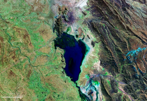
Uru-Uru Lake
| Uru-Uru Lake | ||
|---|---|---|

|
||
| Geographical location | Oruro Department , Bolivia | |
| Tributaries | Desaguadero River | |
| Drain | Desaguadero River | |
| Location close to the shore | Oruro | |
| Data | ||
| Coordinates | 18 ° 4 ′ S , 67 ° 5 ′ W | |
|
|
||
| Altitude above sea level | 3686 m | |
| surface | 260 km² | |
| length | 21 km | |
| width | 16 km | |
| Maximum depth | 1.5 m | |
The Uru-Uru Lake is a lake in the Andes high mountains on the Bolivian Altiplano a few kilometers south of the industrial city of Oruro .
The Uru-Uru lake is one of the remaining lakes of the prehistoric lake landscape of the Ballivián lake . It is fed by Lake Titicaca in the north through the Río Desaguadero , which later supplies Lake Poopó in the south with its water.
The lake is located at an altitude of 3686 m above sea level and has a length of 21 km and a width of 16 km. Its surface is 260 km², its maximum depth about 1.5 meters.
The lake is popular for water sports and fishing.
