Van Rocks
| Van Rocks | ||
|---|---|---|
| Waters | Drake Street | |
| archipelago | South Shetland Islands | |
| Geographical location | 63 ° 5 ′ S , 62 ° 43 ′ W | |
|
|
||
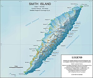
| Map of Smith Island with the Van Rocks (bottom left) | ||
The Van Rocks (from English van 'foremost, at the front' or as a short form of English vanguard 'Vorhut, Vorrupp' ) are two groups of conspicuous pointed cliffs in the archipelago of the South Shetland Islands . They are west of Cape James , the southern tip of Smith Island , at a distance of 3 to 5 km.
The British navigator Henry Foster mapped them in a rough way during his voyage with the HMS Chanticleer from 1827 to 1831 . Scientists from the Falkland Islands Dependencies Survey carried out a more precise mapping in 1959 using aerial photographs of the Falkland Islands and Dependencies Aerial Survey Expedition from 1955 to 1957. The UK Antarctic Place-Names Committee named the rocks that way in 1962 because they are the first geographical objects of the South Shetland Islands when approaching from the west and thus form the vanguard of the other islands of the archipelago .
Web links
- Van Rocks in the Geographic Names Information System of the United States Geological Survey (English)
- Van Rocks on geographic.org (English)
Individual evidence
- ↑ Van Rocks In: Sailing Directions (Planning Guide & Enroute) - Antarctica , Prepared and published by the National geospatial-intelligence agency, (= Pub. 200), 11th edition Springfield, Virginia 2017, p. 136, col. 2 ( English, accessed October 13, 2018).
- ^ John Stewart: Antarctica - An Encyclopedia . Vol. 2, McFarland & Co., Jefferson and London 2011, ISBN 978-0-7864-3590-6 , p. 1630 (English): “ Named by UK-APC on Aug. 31, 1962, for the fact that they mark the westernmost land in the South Shetlands. ”
- ^ Van Rocks in the United States Geological Survey's Geographic Names Information System : “ So named by the UK Antarctic Place-names Committee (UK-APC) because they mark the first or westernmost of the South Shetland Islands. ”

