Smith Island (South Shetland Islands)
| Smith Island | ||
|---|---|---|
| Smith Island as seen from the southeast. | ||
| Waters | Southern ocean | |
| Archipelago | South Shetland Islands | |
| Geographical location | 62 ° 59 ′ S , 62 ° 30 ′ W | |
|
|
||
| length | 32 km | |
| width | 8 kilometers | |
| surface | 205.7 km² | |
| Highest elevation |
Mount Foster 2105 m |
|
| Residents | uninhabited | |
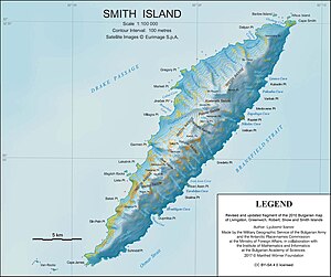
| Map of Smith Island | ||
Smith Island ( Smith Island , sometimes also called Borodino Island ) is an uninhabited, sub-Antarctic island in the archipelago of the South Shetland Islands .
The island was discovered in 1819 by the English navigator William Smith and named after him. In the period that followed, the island was mainly visited by seal hunters . Since there is no research station on the island, it is rarely visited nowadays.
geography
Smith Island is located in the southwest of the archipelago, about 72 km west of Deception Island and is the westernmost island of the South Shetland Islands. Smith Island is about 130 km away from the Antarctic Peninsula . The elongated island is 32 km long, 8 km wide and has an area of almost 206 km². The island has a mountainous topography and reaches a height of 2105 m above sea level in Mount Foster , which is the second highest point in the entire archipelago. The first topographical mapping of the island was carried out by the Bulgarian Commission for Antarctic Geographical Names and the results were published in 2009.
cards
- LL Ivanov: Antarctica: Livingston Island and Greenwich, Robert, Snow and Smith Islands . Topographic map on a scale of 1: 120,000. Manfred Wörner Foundation, Troyan, 2009. ISBN 978-954-92032-6-4
Web links
Individual evidence
- ↑ UNEP Islands (English)
- ↑ Mount Foster on Peakbagger.com (English)


