Mount Foster
| Mount Foster | ||
|---|---|---|
|
Mount Foster as seen from the southeast. |
||
| height | 2105 m | |
| location | Smith Island , South Shetland Islands | |
| Mountains | Imeon Range | |
| Coordinates | 62 ° 59 '48 " S , 62 ° 32' 55" W | |
|
|
||
| First ascent | 1996 | |
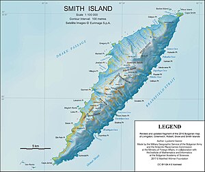
Mount Foster is the highest mountain on Smith Island in the Archipelago of the South Shetland Islands in Antarctica . With a height of 2,105 meters above sea level it provides for the at Clarence Iceland situated Mount Irving is the second highest point of the archipelago is. He is also the highest peak of Imeon Range , the central mountain range to Smith Iceland The first ascent was made on January 30, 1996 by New Zealander Greg Landreth. The survey is named after Henry Foster , a British naval officer and Antarctic researcher.
cards
- LL Ivanov: Antarctica: Livingston Island and Greenwich, Robert, Snow and Smith Islands . Topographic map on a scale of 1: 120,000. Manfred Wörner Foundation, Troyan, 2009, ISBN 978-954-92032-6-4
Web links
- Mount Foster on Peakbagger.com (English)
- About the first ascent (English)
- Mount Foster at the Australian Antarctic Data Center (English)


