Clarence Island
| Clarence Island | ||
|---|---|---|
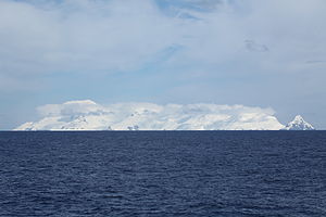
| Clarence Island from the east | ||
| Waters | Southern ocean | |
| Archipelago | South Shetland Islands | |
| Geographical location | 61 ° 13 ′ S , 54 ° 6 ′ W | |
|
|
||
| length | 21.6 km | |
| width | 9.5 km | |
| surface | 161.6 km² | |
| Highest elevation |
Mount Irving 1924 m |
|
| Residents | uninhabited | |
| {{{BILD2-TEXT}}} | ||
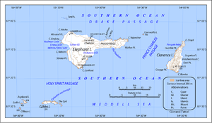
Clarence Island ( Spanish : Isla Clarence ) is the easternmost of the South Shetland Islands , a sub-Antarctic archipelago in the Southern Ocean .
The uninhabited island has the shape of a triangle and is about 18 kilometers long (north-southwest extension) and 161 km² in size. The highest point is Mount Irving with a height of 1924 m above sea level, which is also the highest mountain in the entire archipelago.
The island was discovered by Edward Bransfield on February 4, 1820 and named after William IV , the Duke of Clarence . Bransfield landed at Cape Bowles on the southern tip of the island and made a rough map. A year later the island was mapped again by Fabian von Bellingshausen .
Clarence Island is, like all South Shetland Islands, claimed by several states. However, it falls under the Antarctic Treaty , which does not allow any state sovereignty until 2041.
source
- William James Mills: Exploring Polar Frontiers: A Historical Encyclopedia. ABC-CLIO, Santa Barbara 2003, ISBN 1576074234 , p. 148.
Individual evidence
- ↑ UNEP Islands (English)
- ↑ a b Wills (2003)


