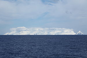
Mount Irving
| Mount Irving | ||
|---|---|---|
|
Mount Irving (left) |
||
| height | 1950 m | |
| location | Clarence Island , South Shetland Islands | |
| Mountains | Urda Ridge | |
| Coordinates | 61 ° 12 ′ 32 ″ S , 54 ° 5 ′ 7 ″ W | |
|
|
||
Mount Irving , formerly Mount Bowles after the nearby Cape Bowles, is at 1950 m or 1924 m above sea level the highest mountain in the archipelago of the South Shetland Islands in Antarctica . It is located in the southern part of Clarence Island , an island in the extreme northeast of the archipelago. The survey is named after Edmund George Irving (1910–1990), a hydrograph in the Royal Navy .
The first ascent was made by a British expedition led by Malcolm Burley on December 6, 1970.
Sources and web links
- Mount Irving on Peakbagger.com (English)
- Mount Irving at the Australian Antarctic Data Center (English)
- William James Mills: Exploring Polar Frontiers: A Historical Encyclopedia. ABC-CLIO, Santa Barbara 2003, ISBN 1576074234 , p. 148.
Individual evidence
- ^ Australian Antarctic Data Center
- ↑ SOUTH SHETLAND ISLANDS Misc 14A and 14B ( Memento of the original from May 18, 2013 in the Internet Archive ) Info: The archive link was inserted automatically and has not yet been checked. Please check the original and archive link according to the instructions and then remove this notice.
- ↑ a b Wills (2003)

