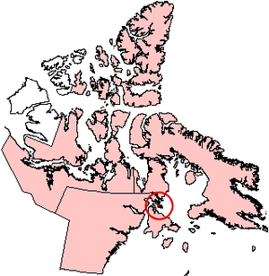
Vansittart Island (Nunavut)
| Vansittart Island | ||
|---|---|---|
| Waters | Foxe Basin | |
| Archipelago | Canadian Arctic Archipelago | |
| Geographical location | 65 ° 50 ′ N , 84 ° 0 ′ W | |
|
|
||
| length | 75 km | |
| surface | 997 km² | |
| Highest elevation | 255 m | |
| Residents | uninhabited | |
Vansittart Island is an uninhabited island in the Canadian Arctic Archipelago . It is located in the Foxe Basin off the east coast of the Melville Peninsula and politically belongs to the Kivalliq region of the Canadian territory of Nunavut . Southwest of the island are White Island and Southampton Island . In between, the Frozen Strait leads to the settlement of Repulse Bay 90 km to the west . Vansittart Island is separated from the mainland by a strait less than 2 km wide.
The island's land area is 997 km². Vansittart Island has a length of 75 km. The highest point on the island is 255 m.
Individual evidence
- ↑ Natural Resources Canada - The Atlas of Canada - Sea Islands ( Memento October 6, 2012 in the Internet Archive )
- ↑ UN SYSTEM-WIDE EARTHWATCH Web Site - Vansittart


