Southampton Island
| Southampton Island | ||
|---|---|---|
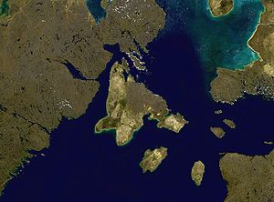
| Satellite photomontage of Southampton Island | ||
| Waters | Hudson Bay | |
| Geographical location | 64 ° 30 ′ N , 84 ° 30 ′ W | |
|
|
||
| length | 355 km | |
| width | 252 km | |
| surface | 41,214 km² | |
| Highest elevation | Mathiasen Mountain 625 m |
|
| Residents | 834 (2011) <1 inh / km² |
|
| main place | Coral Harbor | |
| Map of the island | ||
Southampton Island ( Inuktitut : Salliq ) is an island in northern Canada . It is part of the Canadian territory of Nunavut and belongs to the Kivalliq region.
While in Nunavut summer time generally applies, Eastern Standard Time applies all year round on Southampton Island .
Geography and nature
The 41,214 km² island is located on the northern edge of Hudson Bay and is separated from the Canadian mainland in the west by the Roes Welcome Sound and in the north by the Frozen Strait . On its south coast is the Inuit settlement Coral Harbor with 834 inhabitants (as of 2011).
Characterized by the arctic climate, Southampton Island has tundra vegetation . A large part of the island is almost flat, which is also expressed by the Inuktitut name "Salliq" ("large flat island in front of the mainland"), and only in the northeast do the Porsild Mountains rise to over 600 meters. The highest point is Mathiasen Mountain at 625 meters. Mammals live on the island and a. Polar bears , caribou , arctic foxes , arctic hares , lemmings and ground squirrels . Two important bird sanctuaries are also designated - "East Bay Bird Sanctuary" and "Harry Gibbons Bird Sanctuary" with important nesting sites for the small snow goose ( Anser caerulescens caerulescens ).
history
The first recorded visit to the island by a European traveler was in 1613 by Thomas Button . It is not known exactly when the first people settled on Southampton Island. Undoubtedly, however, predecessors of today's Inuit had settled here many centuries ago , probably people of the Dorset culture , who were ousted by members of the Thule culture from around the year 1000 . An isolated group of people with their own language and culture remained on Southampton Island and the neighboring island of Coats Island until well into modern times, the Sallirmiut ("People of Salliq"). Almost all of them died of gastrointestinal infections introduced by whalers in 1903; Remains of a Sallirmiut camp region are still preserved 64 km southeast of the Coral Harbor settlement.
The island was later repopulated by Aivilingmiut- Inuit, who worked for the American whaler and ethnologist George Comer . He took there 1910-1912, while his schooner AT Gifford was stuck in the ice at Cape Fullerton , a series of sound recordings and collected their legends and ivory carvings, which he gave to the American Museum of Natural History .
Web links
- Parks Canada: Southampton Plains (English)
- Illustrated similar report
- Southampton Island ( English, French ) In: The Canadian Encyclopedia .


