Villingadalsfjall
| Villingadalsfjall | ||
|---|---|---|
|
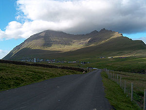
Villingadalsfjall on Viðoy. |
||
| height | 841 m | |
| location | Viðoy Island , Faroe Islands | |
| Coordinates | 62 ° 22 '49 " N , 6 ° 33' 23" W | |
|
|
||
| rock | basalt | |
| particularities | the third highest mountain in the Faroe Islands | |
The Villingadalsfjall is 841 meters above sea level, the third highest mountain in the Faroe Islands .
geography
It is located north of the village Viðareiði , in the far north of the island Viðoy . The well-known steep cliff Kap Enniberg forms the northern part of the mountain. From the summit you have a good view of the six north islands when the weather is clear .
Since the two highest mountains in the Faroe Islands, Slættaratindur and Gráfelli , are on Eysturoy , Villingadalsfjall is the highest mountain on the six north islands, followed by 830 meters high Kúvingafjall on Kunoy. Villingadalsfjall is the northernmost of the ten mountains in the Faroe Islands, which are over 800 meters high, and at the same time the only one located on the island of Viðoy.
See also
Web links
- Fjøll í Føroyum , Umhvørvisstovan, us.fo (in Faroese)
- Umhvørvisstovan: Fjøll í Føroyum flokkað eftir hædd . us.fo. Archived from the original on July 20, 2011. Retrieved in 2016.
- Villingadalsfjall (841m) , hikr.org (German)
Individual evidence
- ↑ Aerial photo of the mountain from 1973 with altitude information : Oyggjahæddir , Umhvørvisstovan, us.fo
- ↑ Føroya Ferðamannablað - Norðoyggjar , 2/2014, issuu.com, page 33


