
Eysturoy
| Eysturoy | |
|---|---|
 |
|
| Waters | North Atlantic |
| Archipelago | Faroe Islands |
| Geographical location | 62 ° 13 ′ N , 6 ° 53 ′ W |
 |
|
| surface | 286.3 km² |
| Highest elevation |
Slættaratindur 882 m |
| Residents | 10,839 (January 1, 2011) 38 inhabitants / km² |
| main place | Fuglafjørður |
 |
|
Eysturoy [ ˈɛstɹɔi ] ( Danish : Østerø , German meaning: East Island ) is the second largest island in the Faroe Islands in the North Atlantic . It is located east of the main island Streymoy, separated by a sound .
The highest mountain on the island and the Faroe Islands is Slættaratindur with a height of 882 m . The island has a total of 66 peaks.
With these data, Eysturoy is not only the second largest Faroese island, but also ranks second in terms of population. Important centers are Fuglafjørður in the north and the agglomeration of the municipalities of Runavík and Nes / Toftir in the south.
Eysturoy is connected to Streymoy by a car bridge. The islanders call it (jokingly) the only car bridge across the Atlantic . The settlement area of Runavík used to be reached more quickly by car ferry from the capital Tórshavn . Today you are forced to drive the 63 kilometers to Toftir on the country road. Another important local ferry port is Leirvík on the east coast. From here you can get to the North Islands with the second largest Faroese city Klaksvík . This ferry was also discontinued in August 2006 because the 6.2 km long North Island Tunnel, which was punctured according to plan in June 2005, is being opened.
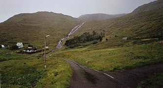
The most famous sights on Eysturoy are Eiði with a picturesque location in a dramatic landscape; Gjógv , one of the most popular photo opportunities through its small natural harbor in a crevice; Gøta with the Blásastova Museum and the thermal spring of Fuglafjørður ( varmakelda ), which testifies to the volcanic origin of the archipelago. A steep pass road leads between Eiði and Gjógv / Funningur over the 392 m high Eiðiskarð, which lies directly below Slættaratindur, the highest mountain in the Faroe Islands at 882 m.
The legendary basalt columns Risin and Kellingin are also located on the northern tip of Eysturoy . Also worth mentioning are the small forests on the island of Eysturoy, of which Viðarlundin í Søldarfirði with an area of 1.72 hectares and Viðarlundin á Selatrað with 1.55 hectares are the two largest.
Forest near Selatrað
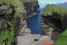
Harbor in a crevice near Gjógv
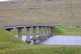
Bridge over the Atlantic at Oyrarbakki


Individual evidence
- ↑ Elttør, Eyðun: Uppskot til løgtingslóg um viðarvøkstur og frílendisrøkt , Tab. (Talva) 2, Løgting, March 4, 2003.