
Vágar
| Vágar | |
|---|---|
 |
|
| Waters | Atlantic Ocean |
| Archipelago | Faroe Islands |
| Geographical location | 62 ° 5 ′ N , 7 ° 16 ′ W |
 |
|
| surface | 175.4 km² |
| Highest elevation | Árnafjall 722 m |
| Residents | 3042 (2013) 17 inhabitants / km² |
| main place | Sørvágur |
 |
|
Vágar [ ˈvɔːar ] also Vágoy ( Danish Vågø , German meaning: "bays (island)") is the third largest island in the Faroe Islands in the North Atlantic . The international (and only) airport of the small island nation is located here.
The island
The name of the island Vágar goes back to the plural form of the word vágur . This word is used to describe a bay. In the literal sense, Vágar therefore means "bays". This means the three bays on the island ( Sørvágur , Miðvágur and Sandavágur ).
.JPG)
Vágar is located west of the main island Streymoy and has been connected to it since 2002 by the approx. 4 km long Vágar tunnel . This tunnel is the most ambitious construction project in the history of the Faroe Islands to date and shortens the travel time between Vágar Airport and the capital. To the west of Vágar are the Tindhólmur and the 'bird paradise', the island of Mykines . Together they form the Vágar region , one of the six Syssel of the Faroe Islands.
A total of 41 peaks are distributed over the mountainous island, with the two highest peaks in the northwest: the 715 meter high Eysturtindur and the highest mountain on the island at 722 meters, which is called Árnafjall ( Eagle Mountain ).
Vágar also has the two largest inland lakes in the Faroe Islands: Sørvágsvatn / Leitisvatn and Fjallavatn . While the latter is one of the few nature reserves in the Faroe Islands, the former is a popular destination, where all Faroese landforms are close together. The Trælanípa cliff is famous , from which slaves allegedly unable to work were thrown into the sea. Also on the island are some of the most famous waterfalls in the Faroe Islands, including the Bøsdalafossur in the south, the Múlafossur near Gásadalur in the west and the Reipsáfossur in the north.
Archaeological finds such as the Sandavágsstein have shown that Vágar was already settled on the Faroe Islands during the Viking Age . Sørvágur , Miðvágur and Sandavágur can look back on 1000 years of history. Every spring on March 1st, the regional Várting (spring thing) met in Miðvágur .
The youngest place on the island is Vatnsoyrar , the only place in the Faroe Islands that is not by the sea. When the Faroe Islands were occupied by Great Britain in World War II , they had their largest contingent of troops here because of the proximity to the airport. Vágar was a security zone back then, and anyone wishing to enter the island needed a special pass. The contact between the locals and the soldiers is described as cordial. Friendships and marriages developed at that time.

Faroese postage stamp from 2003.
In the west of the island are the small villages of Bøur and Gásadalur . Gásadalur was one of the most isolated villages in Europe until 2004 . Since then it has been connected to the outside world by a tunnel. The postman, who until then had to walk the difficult - and popular among tourists - hiking trail from Bøur to Gásadalur several times a week, had the honor of doing the first blast for the tunnel and being the first to walk through the completed tunnel.
However, two other isolated places on Vágar were abandoned: Víkar, despite its agriculturally advantageous conditions, in 1910 , and Slættanes , although it is considered to be particularly scenic, in 1964 . Old hiking trails form a network over the entire island and enable natural excursions to the now uninhabited northern part of Vágar.
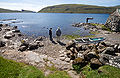
Pictures from Vágar
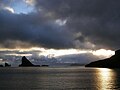
Drangarnir, Tindhólmur and Gáshólmur.

The Dalsá brook, which flows as a waterfall into the Atlantic at Gásadalur.
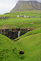
Waterfall near Gásadalur with Árnafjall in the background.

The waterfall as a natural spectacle is a popular photo opportunity.

In the village of Gásadalur.
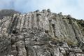
Basalt columns at Gásadalur.

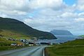
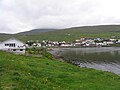
Bøur
Sørvágur and Mykines

The church in Sørvágur.
Sørvágsvatn.

Vatnsoyrar.
The place Miðvágur.

The church in Miðvágur.

The place Sandavágur.


.jpg)


.JPG)

The two parishes
Since the beginning of 2009 there are still two municipalities on the island: the municipality of Sørvágur ( Sørvágs kommuna ) in the western part of the island including Bøur , Gásadalur and Mykines as well as the bay municipality of Vágar ( Vága kommuna ) in the eastern part of the island, consisting of Miðvágur including Vatnsoyrar and Sandavágur , where the municipal administration is also located. Miðvágur and Sandavágur were independent municipalities until the end of 2008.
The bay community Vágar ( Vága kommuna ) on the island of Vágar should not be confused with the bay community Vágur ( Vágs kommuna ) on the island of Suðuroy .

The municipality of Sørvágur ( Sørvágs kommuna ) in the west of the island.

The bay community ( Vága kommuna ) in the east of the island.

Location of the Syssels Vágar in the Faroe Islands


Web links
- Sørvágs kommuna - Website of the municipality of Sørvágur ( Sørvágs kommuna )
- Vága kommuna - website of the bay municipality ( Vága kommuna )
Individual evidence
- ↑ Gásadalur ( Memento of the original from June 29, 2016 in the Internet Archive ) Info: The archive link was inserted automatically and has not yet been checked. Please check the original and archive link according to the instructions and then remove this notice. , visitvagar.fo