
Kunoy (island)
| Kunoy (island) | |
|---|---|
 ( mountain heights partly inaccurate! ) |
|
| Waters | Atlantic Ocean |
| Archipelago | Faroe Islands |
| Geographical location | 62 ° 18 ′ 16 ″ N , 6 ° 39 ′ 12 ″ W |
 |
|
| surface | 35.5 km² |
| Highest elevation | Kúvingafjall 830 m |
| Residents | 142 (September 1, 2016) 4 inhabitants / km² |
Kunoy [ ˈkuːnɪ ] "Women's Island " (Danish: Kunø ) is one of the 18 islands in the Faroe Islands and is one of the six North Islands .
Surname
Kunoy is also the name of the main town on the island and the name of the Faroese community Kunoy ( Kunoyar kommuna ), which is made up of the two villages on the island. The community of Kunoy (and thus the island) had exactly 142 inhabitants in September 2016. Of these, 73 residents were in Haraldssund and 69 in the village of Kunoy .
- Origin of name
The name comes from a rocky cliff at the northern end of the island, which is east of Kunoyarnakkur . This rock is called Konan ("the woman").
Location and shape
The elongated island, which extends over 14 kilometers from north-northwest to south-southeast, is the counterpart to the neighboring island of Kalsoy to the west , the "men's island". Both are separated by the Kalsoyarfjørður strait , and both consist of a ridge that runs the length of the island. The northern tip of Kunoy forms Cape Kunoyarnakkur. The east coast of Kunoy is separated from the neighboring island of Borðoy by the Haraldssund , a strait . In the southern part of the east coast there is also the second place on the island of Kunoy: Haraldssund .
The mountainous nature of the island is particularly emphasized by the fact that six of the ten Faroese mountains over 800 meters are located on Kunoy alone. These are the 830 meter high summit Kúvingafjall , the 825 meter high Teigafjall , the 819 meter high Kunoyarnakkur , the 818 meter high Havnartindur , the 817 meter high Urðafjall and the 805 meter high Middagsfjall .
The villages on Kunoy
The village of Kunoy, sometimes also called Kunoyarbygd , is located on the steep west coast of the island of the same name and has 69 inhabitants. Kunoyarbygd is the older and was also the larger of the two villages on the island until 2015. Therefore, the seat of the municipal administration is also located here. In 1886 the village got its first school. In 1914, a tree planting was planted near the village, which has meanwhile developed into a wood with an area of approximately 7,800 m², the Viðarlundin í Kunoy . A special feature of this grove is a mighty boulder that was transported here by ice age processes. The tree planting, which consists mainly of conifers, is one of the smallest in the Faroe Islands.
An approximately three-kilometer-long tunnel has existed since 1988, connecting the village of Kunoy with the 73-inhabitant village of Haraldssund on the east coast. Together they form the community of Kunoy ( Kunoyar kommuna ). In mid-2016 the community had 144 inhabitants.
There used to be a third place on Kunoy: Skarð on the east coast. It was given up when all the men in the village got into distress while fishing in 1913 and drowned.
The legend tells that the characteristic basalt steps on a mountain slope of the island represent the imprint of the planks of Noah 's Ark , which is said to have landed here. To be sure, no such plank has ever been found to support this.
Transport links
Kunoy has been connected to the neighboring island of Borðoy in the east by a road dam near Haraldssund since 1986 . From the dam path it goes over the Ánavegur to Klaksvík . The 504 bus runs regularly on the Klaksvík- Ánir- Haraldssund-Kunoy route , replacing the ferry that used to serve the island in public transport.
photos

The Kunoyarnakkur in the north of Kunoy. Cape Enniberg on Viðoy can be seen in the background .
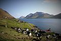
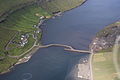
Kunoy village seen from the north. In the background Kalsoy.

The main town Kunoy.
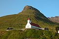
Kunoy Church.

The pier in the village.

The grove near the village of Kunoy.
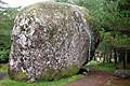
Ice age boulder in Kunoy grove.

The Skarðsgjógv gorge near Skarð.
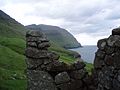
View from the remains of houses in Skarð in north direction.

Haraldssund

The causeway over the Haraldssund between Kunoy and Borðoy.
The dam path viewed from above.

View of the south end of Kunoy with Brattanes .


.JPG)
.JPG)


.jpg)

.JPG)


people
- Símun av Skarði (1872–1942), educator, founder of the Faroe Islands folk high school and poet of the Faroese national anthem Tú alfagra land mítt .
See also
Web links
- Kunoyar kommuna - Official website of the municipality of Kunoy (in Faroese)
- Faroeislands.dk: Kunoy (in English, info. And photos)
- Faroeislands.dk: Haraldssund (in English, info. And photos)
Individual evidence
- ↑ Størsti fólkavøkstur í einum ári síðani skjálvtarnar eftir stóra skrædlið fyrst í 1990-unum , hagstova.fo, October 13, 2016
- ↑ Fjøll í Føroyum , Umhvørvisstovan, us.fo (in Faroese)
- ↑ a b Fólkatal , hagstova.fo
- ↑ Kunoy , visitfaroeislands.com
- ↑ Viðarlundin í Kunoy , visitfaroeislands.com
- ↑ Andrias Højgaard, Jóhannes Johansen and Søren Ødum: Træplanting í í Føroyum eina old , Føroya Fróðskaparfelag, Torshavn 1989
- ↑ kommunan , kunoy.fo
Eiðis | Eystur | Fámjins | Fuglafjarðar | Fugloyar | Hovs | Húsavíkar | Hvalbiar | Hvannasunds | Klaksvíkar | Kunoyar | Kvívíkar | Nes | Porkeris | Runavíkar | Sands | Sjóvar | Skálavíkar | Scopunar | Skúvoyar | Sumbiar | Sunda | Sørvágs | Tórshavnar | Tvøroyrar | Vága | Vágs | Vestmanna | Viðareiðis