Koltur
| Koltur | |
|---|---|
| Waters | Atlantic Ocean |
| Archipelago | Faroe Islands |
| Geographical location | 61 ° 59 ′ 39 ″ N , 6 ° 58 ′ 27 ″ W |
| surface | 2.3 km² |
| Highest elevation | Uppi á Oyggj (Kolturshamar) 477 m |
| Residents | 1 (January 1, 2016) <1 inhabitant / km² |
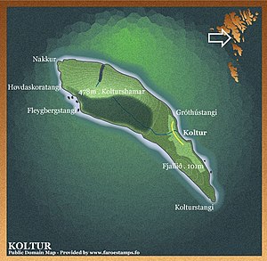
| Map of Koltur | |
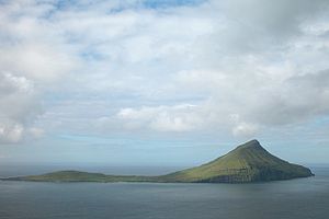
Koltur [ ˈkɔltʊɹ ] ( Danish : Kolter ) is one of the 18 islands of the Faroe Islands and belongs to the region of the main island Streymoy and the municipality of Tórshavn . At the same time it has the status of an "outer island" ( Útoyggj ).
island
Koltur is the second smallest island in the Faroe Islands. Also in the list of the Faroese Islands, which is ranked by population, it is next to last. Then there is only the uninhabited island of Lítla Dímun .
Koltur is first mentioned in writing around 1350 to 1400 in the so-called dog letter . In the royal property register from 1584, the so-called Jarðarbókin , two farms on Koltur are listed.
The settlement history of Koltur corresponds to that of the neighboring island of Hestur .
Surname
The origin of the name is uncertain. Some believe that it is a very old Anglicism in the Faroese language ; H. is derived from colt - "foal", i.e. Hestur and Koltur - the horse and the foal . Others, on the other hand, suspect an origin from the Old Norse word koltr , the meaning of which, however, is not clearly clarified. The inflected forms of the name of Koltur are í Koltri (in Koltur) and úr Koltri (from Koltur).
Settlements
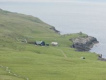
Two larger settlements can be found on the island, which were also mentioned in the list of goods from 1584. On the one hand the older, now abandoned settlement Heimi í Húsi and on the other hand the still inhabited homestead Norðuri í Gerðum of more recent date, which is also known as Koltursgarður .
Once upon a time, 50 people lived on four farms on Koltur. It is said that in the past two local families stopped talking to each other. In the end, nobody knew the reason for this. The island was uninhabited between 1989 and 1990 until a couple from Kirkjubøur settled here and left the island in 2009. After their daughter and her family settled on the island for a short time in 2009, only one person has lived on Koltur since 2011.
The old farmhouses on the island date back to the 16th century and are among the special cultural and historical treasures of the Nordic countries . The island is now subsidized by the Faroese state, and there are plans to reconstruct an old homestead, among other things to stimulate tourism on the island, but mainly because of the preservation of monuments . There are even plans to turn the whole island into a national park.
There is no longer a regular ferry connection to Koltur, only in the summer months the island can be visited for excursions when the weather is good. However, there is the possibility to visit the island with a helicopter that flies to Koltur three times a week.
See also: List of cities and towns in the Faroe Islands
Pictures from Koltur
Web links
- Hestur and Koltur , VisitFaroeIslands, page 44
- KOLTUR, THE ISLAND . faroestamps.fo. Archived from the original on May 25, 2011. Retrieved October 28, 2016. Faroestamps.fo about Koltur (German, English, French, Danish, Faroese)
- Koltursgarður - The island of Koltur and its inhabitants (Faroese, one page also in English)
- Heimasíða , heima.olivant.fo (About the island - in Faroese)
- Timetable , current helicopter timetable for Koltur (Wednesdays, Fridays and Sundays)
- Faroeislands.dk: Koltur (in English, info. And photos)
Individual evidence
- ↑ Hvussu gomul er bygdin , heimabeiti.fo (in Faroese)
- ↑ On page 56, two farms are listed under the Danish name Kolter : Jarðarbókin
- ↑ The Jarðarbókin 1584 is the oldest surviving register of royal estates on the Faroe Islands ( Jarðarbókin 1584 )
- ↑ Koltur , utoyggj.fo (in Faroese)


