
Oyrareingir
|
||

|
||
| position | 62 ° 6 ′ N , 6 ° 58 ′ W | |
|
Resident rank |
42 (2007) 73 |
|
| Commune | Tórshavnar kommuna | |
| Post Code | FO 415 | |
| Markatal | - | |
|
Grammar dative (in / from ...) genitive (after ...) |
á / av Oyrareingjum Oyrareingja |
|

Oyrareingir is a place in the Faroe Islands on the east coast of Streymoy .
The name Oyrareingir is made up of oyri (flat sandy bay, plural oyrar ) and ong (meadow, plural eingir ), which means "sandy beach meadows ".
Oyrareingir is at the end of the Kollafjørður fjord . Coming from Tórshavn it can be reached through the Kaldbaksbotnur tunnel . At the exit of the tunnel, Oyrareingir is on the left. Signabøur is in the immediate vicinity .
Oyrareingir is so small that it is not shown on most maps.
A modern industrial port was inaugurated here on March 7, 2009.
photos
Oyrareingir

Oyrareingir

Oyrareingir

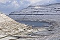
The three villages at the end of the fjord: Oyrareingir on the left, Signabøur on the right and Kollafjørður in the background.

.JPG)
.JPG)

Web links
- Oyrareingir , faroeislands.dk (in English)
- Container Port at Oyrareingjum , jkp.fo (in English)