
Hestur
| Hestur | |
|---|---|
 |
|
| Waters | Atlantic Ocean |
| Archipelago | Faroe Islands |
| Geographical location | 61 ° 57 '17 " N , 6 ° 53' 15" W |
 |
|
| surface | 6.1 km² |
| Highest elevation | Eggjarrók and Múlin 421 m |
| Residents | 27 (January 1, 2011) 4.4 inhabitants / km² |
| main place | Hestur |
 |
|
Hestur [ ˈhɛstʊɹ ], also Hestoy [ ˈhɛstɔi ] (literally: horse [e-island], Danish name: Hestø ) is one of the 18 islands of the Faroe Islands and belongs to the region of the main island Streymoy and the municipality of Tórshavn . At the same time it has the status of an "outer island" (see Útoyggjar ).
- Population density: 4.4 inhabitants / km²
- Number of peaks: 3 (with single counting of the double peaks)
- Múlin 421 m
- Eggjarrók 421 m
- Nakkur 296 m
- Álvastakkur 125 m
- Municipality : Tórshavnar kommuna
Hestur and Koltur can be viewed particularly well from the historically significant town of Kirkjubøur on Streymoy.
History and geography
The settlement of Hestur, which is around 5 km long and around 1 km wide, probably dates back to the Viking Age on the Faroe Islands , or at the latest to the Middle Ages . Corresponding finds have been made at the southern tip of Hælur.
Climatically, Hælur is due to the southern slope favorable for grain cultivation but bad for fishing , so that the islanders have moved to the east coast to today's place Hestur.
Infrastructure
In the clear highlands of Hestur there are several small mountain lakes in the area called Fagradalsvatn. You can camp here. For many people it may be too cold to swim there, and despite the small number of residents, Hestur has its own swimming pool. It was completed in 1974. There are no longer any shopping opportunities on Hestur. However, the island still has its own school. The village church dates from 1910 and was renovated in 2006/2007. Instead of a church tower, it has an unusual hexagonal roof turret .
Transport and economy
Hestur used to be served by a line ferry from Tórshavn . There is now the new port of Gamlarætt at the southern tip of Streymoy , which considerably shortens the already short passage. Today the Spógvin passenger ferry and the Teistin passenger and car ferry operate on this route. The blasted rocks were - after thirteen years of planning and preparation - used to build a new quay for the small fishing port of Hestur, on which the island (in addition to agriculture) lives.
An undersea tunnel from the main island of the Faroe Islands, Streymoy , to the island of Sandur is currently under discussion, the Sandoy Tunnel . It should run in parts under Hestur. In this context, the residents of Hestur repeatedly demanded that an exit to Hestur should be built from the tunnel so that the connection from Streymoy to Hestur can also be improved through it.
A paved path leads south from the village along the east coast of the island. It is easy to walk to the southern tip of Hestur and the Hælur area, from where there is a beautiful view of the neighboring island of Sandur with the port of Skopun .

Hestur swimming pool

Hestur
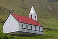
Hestur Church

Church interior

Center, main street

Main street, southern part
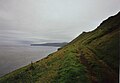
East coast with a view to Sandur

Southern tip of Hestur with a view of Skopun on Sandur


See also
Individual evidence
- ↑ Liv Kjörsvik Schei: The Faeroe Islands , 188. Edinburgh, of 2003.
- ↑ Liv Kjörsvik Schei: The Faeroe Islands 189. Edinburgh., 2003
Web links
- Faroeislands.dk: Hestur (in English, info. And photos)