
Kalsoy
| Kalsoy | |
|---|---|
 |
|
| Waters | Atlantic Ocean |
| Archipelago | Faroe Islands |
| Geographical location | 62 ° 18 ′ N , 6 ° 44 ′ W |
 |
|
| length | 18 km |
| width | 1 km |
| surface | 30.9 km² |
| Highest elevation | Nestindar 788 m |
| Residents | 107 (January 1, 2011) 3.5 inhabitants / km² |
| main place | Mikladalur , Húsar |
 |
|
Kalsoy [ ˈkalsɔi ] (literally: "Man Island", old Faroese spelling also Kallsoy, Danish name Kalsø , older spelling Kalsøe or Kalsöe , Calsoe ) is one of the 18 islands of the Faroe Islands and belongs to the region of the six North Islands . At the same time it has the status of an "outer island" (see Útoyggjar ).
There are four places on the east coast of Kalsoy: Trøllanes (19 inhabitants) and Mikladalur (34 inhabitants) in the north used to form an independent Faroese municipality (Mikladals kommuna). Today they belong to the North Island metropolis of Klaksvík . The two places in the south, Húsar (47 inhabitants) and Syðradalur (6 inhabitants), remained independent as Húsa kommuna until 2016 and have also been part of Klaksvík since 2017.
A fifth place, Blankskáli , was abandoned at the beginning of the 19th century.
geography
Kalsoy is about 18 km long and 1 to 3 km wide and the counterpart to the eastern neighboring island Kunoy ("women island "). Like Kunoy, Kalsoy is made up of a single ridge that extends from northwest to southeast.
Both islands are separated from each other by the Kalsoyarfjørður . In the west, Kalsoy is separated from Eysturoy by the relatively wide Djúpini strait , which is followed by the Leirvíksfjørður to the south . In the southeast is the island of Borðoy .
The very steep and inaccessible west coast consists partly of bird mountains. Bay Kalsvík is known in the north with the largest Faroese kittiwake colony (see Faroese birds ). The island slopes gently towards the east. On this side there are deep valleys with the four settlements.
At 788 meters, Nestindar in the north is the highest mountain on the island. The second highest mountain is the Botnstindur at 743 m.
Transport and tourism

There are regular ferry connections from Strandfaraskip Landsins between Klaksvík and Syðradalur, the ferry Sam runs 2 to 3 times a day. The ship used to call at the other locations as well, but today they are all connected by a system of tunnels that was completed in 1986 . The elongated island is popularly known as the " recorder " because of the many tunnel openings . See also: List of tunnels in the Faroe Islands
You can bring your own car with you via the ferry from Klaksvik (the ferry holds around 20 cars), and there is a bus from Húsar to Trøllanes 2 to 3 times a day.
The northern tip of Kallur is reached from Trøllanes on a hiking trail. One of the Faroe Islands lighthouses is located here , and the view is said to be unique.
people
- Hans í Mikladali (1920–1970), painter
- Bjørn Kalsø (* 1966), politician
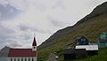
Húsar

Húsar Kirkja

Mikladalur

Mikladalur

Trøllanes


