
Sandoy
| Sandoy | |
|---|---|
 |
|
| Waters | Atlantic Ocean |
| Archipelago | Faroe Islands |
| Geographical location | 61 ° 51 ′ N , 6 ° 47 ′ W |
 |
|
| surface | 112.1 km² |
| Highest elevation | Tindur 479 m |
| Residents | 1393 (December 31, 2002) 12 inhabitants / km² |
| main place | Sandur |
 |
|
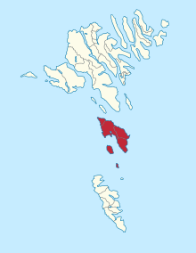
Sandoy [ ˈsandɔi ] / [ ˈsandi ] ( Danish Sandø , German meaning sand island ) is the fifth largest island in the Faroe Islands . The island has 19 peaks, the highest of which is Tindur at 479 m .
The offshore small islands Skúvoy and Stóra Dímun with a total of 62 inhabitants belong to the Sandoy region . They form the municipality of Skúvoy. There are four municipalities on Sandoy with six towns: Sandur , Skálavík , Skopun and Húsavík (with Dalur and Skarvanes ).
Sandoy, the sand island, takes its name from the sandy beaches on its coast. In terms of landscape, it is considered to be the "flattest of the large islands" among the very rugged islands of the Faroe Islands. There are no tunnels or steep mountain roads here, so Sandoy is great for cycling. A small water mill by Sandoy from the 18th century can be seen in the open air museum of the Danish National Museum north of Copenhagen .
Sandoy is connected to the capital Tórshavn by a car ferry via the newly built ferry port Gamlarætt . In 2004, a feasibility study was commissioned to calculate the submarine Sandoy tunnel to Skopun .
Web links
- visitsandoy.fo - Tourist guide (English)