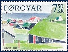
Dalur
Dalur [ ˈdɛalʊɹ ] ( Danish : Dal , literally: valley ) is a place in the Faroe Islands , the southernmost of the island of Sandoy .
- Population: 49 (January 1, 2007)
- Postal code: FO-235
- Municipality : Húsavík (Faroe Islands)
Dalur is located in the south of Sandoy on the east coast in a large valley (hence the name) and has a relatively large commons. In a southerly direction, a narrow road leads to the southern tip of Sandoy, from where you can walk to the Skorin bird rock . Large schools of puffins stay here during the breeding season. This is beneficial for the growth of plants, which is why the meat of the sheep turns out very good.
Dalur is an old village that was mentioned for the first time in 1404 , although old documents indicate that it was also called Varmadalur ("warm valley"). It is hardly as old as the other two villages - Skálavík and Húsavík on the east side of the island. The village is relatively isolated, especially as there has only been a road connection since 1963. The road runs along steep mountain slopes, which is why it is not uncommon for stone and earth to slide onto the road. There are now plans for a road tunnel through the mountains between Húsavík and Dalur.
Dalur Church was built in 1957, making it the first church in the village.
Mainly the inhabitants do agriculture and fishing. In 1989 the place received two new trawlers.
See also
Web links
Individual evidence
Coordinates: 61 ° 47 ′ N , 6 ° 41 ′ W

